
![]()
Tri-County Genealogical Society
"because the trail is here"
Phillips - Lee - Monroe Counties in Eastern Arkansas

Published 2020
The first communities to establish what we might think of as towns or villages were in the area surrounding the mouth of the St. Francis River, between the Mississippi River and Crowley’s Ridge. The first of these settlements, Utica, is thought to have been developed close to the ridge, at the mouth of the St. Francis River, between 1803 and 1805. The first statewide mention of this town was in 1819, in the first issue of the Arkansas Gazette. According to the paper, there were one hundred residents of this ancient town, -note it is called ancient in 1819-.with a gentleman by the name of McLain owning a tavern on the Island close to the mouth of the St. Francis. Josiah Shinn in “Pioneers and Makers of Arkansas” states, “Utica was a flourishing town of some possibilities in 1819, but gave place in time to the greater glory of Helena”. Records show that many marriages were performed at Utica, and many Arkansans date their origins from this early village. In the same neighborhood, at a somewhat later date, was the town of Shirley, but it soon faded away with the growth of St. Francis (Helena). Early maps show Utica as a settlement, but not St. Francis, however, by 1827, St. Francis had earned a place on state maps.
Utica’s growth around 1817 was due to people awaiting the results of the first survey of the area. They had in hand, old Spanish Land Grants, military land warrants, New Madrid certificates, or certificates of purchase from the United States Government. In year of 1817, Utica was laid out as a town by Nicholas Rightor, land boundaries were set, and for the first time, settlers knew where their property lines were drawn.
While Utica was flourishing, the settlement of St. Francis (Helena) was also expanding. Sylvanus Phillips and W.B.R. Hornor had moved to St. Francis, as had others who had had graced Utica during the early years. No one is certain as to when the name changed from St. Francis to Helena, but by 1821, the name Helena was officially supplanted in the Arkansas Gazette, and the new name remained.
Thanks to the efforts of W.B.R. Hornor, on May 1, 1820, Arkansas County was divided and Phillips County was created from this division and named after Sylvanus Phillips. An old fashioned barbeque was held on July 4, 1821, a year later, to celebrate the occasion. Guns were fired, strong spirits served, ’beeves’ roasted, and all enjoyed it so much that the festivities were held each year for the next fifteen years.
In the late 1820’s, efforts were organized to incorporate Helena as an official city. Phillips had donated the land for the town site, and in 1833, the town was incorporated and named officially after Sylvanus Phillips’ deceased daughter, Helena Phillips. Helena Phillips died on August 28, 1831, after a lengthy illness, and her father Sylvanus did not live to see the town incorporated as he passed away October 31, 1830.
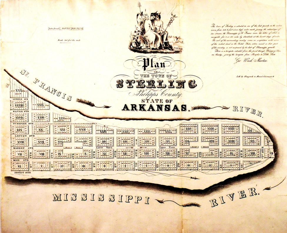
While the town of Utica was dwindling by 1830, works were under way to develop a new community called Sterling at the mouth of the St. Francis River. It is difficult to determine the exact lifespan of this settlement. Postal records show that it was a post office as early as 1848, and was discontinued as such in 1866. Maps of 1845, 1860 and 1888 show Sterling as a town, however, a map of 1878 Department of the Interior map show the mouth of the St Francis river as a settlement but not named Sterling. It is believed that the Martin family developed the plans for this community as tax rolls show several Martin families, all related, owning lots and acreage in Sterling, and taxed from 1840 – 1850. Sterling was platted as a town site with lots to be sold. (The plat map below has the name of George Washington Martin as the submitter.) Lot numbers go as high in 585 in 1849. Originally, lots sold from $10.00 and acre to $50.00 an acre. By 1850, the price of the $10.00 lots had dropped to $3.00, and the $50.00 lots to $8.00. Unimproved lots in 1850 varied from $10.00 to $67.00 per acre, while improved lots ranged from $100.00 to $600.00.
Whether Sterling was started as a place to benefit from the steamboat trade, or to benefit from the lumber trade in the area is not known. There were many woodyards, as well as stave making groups in the area as late as the beginning of the Civil War.
County Court records make several references to the start of trade at Sterling. Joseph Wallen petitioned the Court in 1845 for a license to keep a public ferry across the Mississippi River from Sterling. In 1844 and 1845 several licenses were granted to individuals to keep grocery, retail and vinous spirits shops. The 1840’s were the years in which Sterling seemed to prosper. Overseers were appointed to work on and keep up the road from Helena to Sterling, and to oversee the road that led from Sterling to Phillips Bayou.
As the years passed, many of the residents of Sterling moved closer to Helena. Baker Sparkman, who lived at the mouth of the St. Francis in the 1960’s and 70’s, remarked that the site of his house was at the center of the old town of Sterling, and that his grandmother had planted the cedar trees which were still standing in 2015. If this is the case, and as large as the plat map of Sterling is, that means that a part of Sterling, as some have said, washed into the Mississippi River. (For anyone interested in viewing the once populous town, take the Low Road to the sign that directs you to the mouth of the St. Francis, turn right and continue until you get to the end of that road and are forced to take a left. You will now be in the center of the old town. The cedar trees are on the right, across from the Mississippi River State Park signage.)
Up and until the Mississippi River Park took possession of the area around the mouth of the St. Francis River, there was a rope swing that hung from a tree on the left side of the road, in a field behind the new signage. Legend has it that a little girl lived at Sterling and this was her swing. After she died, at a very tender age, her ghost could be seen in the early evening swinging in her beloved swing. As the swing decayed, locals would replace it, so that the child ghost could continue her favorite pastime. The swing was removed about 2016 , and there have been no reported sightings of the child since that time.
Primary sources for these articles include the Phillips County Historical Quarterlies, Shinn's Pioneers and Makers of Arkansas; Biographical and Historical Memoirs of Eastern Arkansas; Down the Great River by Glazier; Arkansas Historical Documents and Land Grants; The Encyclopedia of Arkansas History and Culture; Courts and Lawyers on the Arkansas Frontier; Mark Twain's Life on the Mississippi; USGenWeb; Ancestry.com; FamilySearch.org; Phillips DNA Project.
If you have questions or problems with this site, email the TCGS Coordinator, Ms. Carrie Davison, or the Webmaster, Ms. Debra Hosey.
Please do not ask for specific research on your family here. Use the Research Help page instead.