
![]()
Tri-County Genealogical Society
"because the trail is here"
Phillips - Lee - Monroe Counties in Eastern Arkansas

Published 2020
Last week we were given a glimpse of the treasures that may be lurking in Crowley’s Ridge, including the possibility of cannons left behind after the Civil War. Having spoken personally with M J Lederman of West Helena, we have verbal confirmation that as of twenty – thirty years ago there was a cannon still located in Crowley’s Ridge. Mr. Lederman remembers seeing the cannon when he was about ten years old on the west side of the ridge in the vicinity of the old logging road near the gravel pits off the Low Road.
The other confirmations come from gentlemen who Major James M. Massey, USAR, interviewed in the mid and later 1960’s. Major Massey was a lifelong researcher of the Civil War in Helena, and spent extensive time interviewing locals, and gathering information from The Library of Congress concerning reports of the Confederate Army’s activities, including their travels to Helena, as well as skirmishes that took place out in the St. Francis National Forest. The Phillips County Historical Quarterlies (Volume 7 # 4, and Volume 8 #2) have Major Massey’s in-depth reflections of his interviews, with specific details of location, description, and thoughts on accurate information. Due to the length of these articles, a summary of Major Massey’s findings follows.
Candy Delks, formerly of La Grange, was marking trees with a Mr. N Fisher, for the St. Francis Forest Service when they came upon old brass cannon in a ravine in 1952. They said the cannon was thirteen feet long and twelve inches wide at the muzzle. They marked the coordinates on a map, but the map was never located by Major Massey. Paralleling Candy Delks description of the location of the cannon in a ravine is that of Barney Buford from Lee County. Mr. Buford was logging when he stumbled across the cannon. He was walking in a ravine when he came upon three small springs bubbling out of the ground, with the cannon a short distance from the springs. It was covered with dirt except for about two feet of the muzzle end. Mr. Buford said he was coming from Marianna. From the Storm Creek Dam, he went about three miles south on the Storm Creek Road, turned right onto the ridge, and then went north for about two miles, and was in a deep ravine when he found the cannon. According to Major Massey, both Delks and Buford place the cannon in the same area.
Still another report comes from Howard Griffin of Helena. Mr. Griffin was squirrel hunting about thirty years ago when he came upon a cannon. When questioned as to the location, Mr. Griffin states that he took the Storm Creek Road, north from 4th Street, to the second gate on the left, and walked about one half a mile back into the forest when he spotted the cannon. This location also seems close to the location Delks and Buford spoke about.
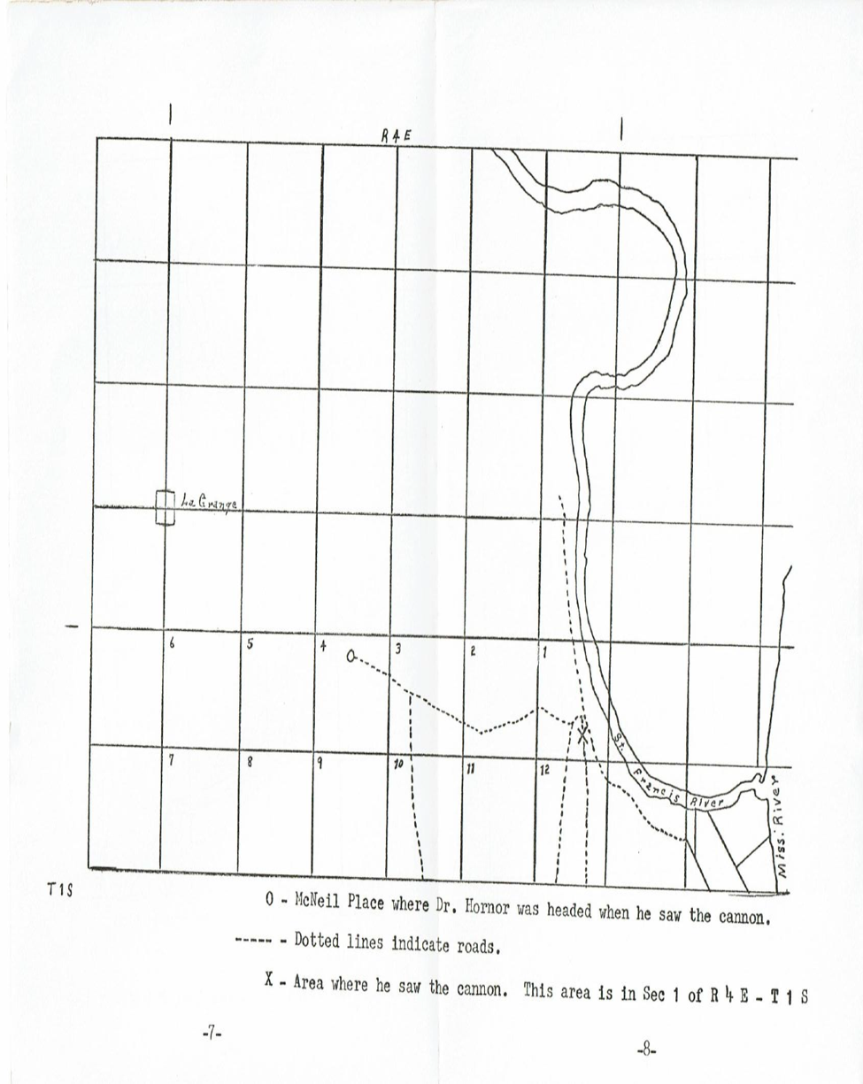
Mr. Porter Young (Helena World Publishing) reported to Mr. Massey that he had seen a cannon when he was about fourteen, near Distillery Branch. He and other members of his scout troop played around the old weapon. Another scout member, Mr. Bill Cushman, confirmed the story, and stated that the cannon was near an old granary on Big Springs Road (also called the Sterling Road and the Low Road). Dr. Albert A Hornor, when riding from the Sebastian Plantation to the McNeil place discovered a cannon while searching for the remains of a distillery on Distillery Branch. This cannon is in the approximate location of the cannon viewed by Mr. Porter Young and Mr. Bill Cushman, and possibly M J Lederman. (A copy of the map drawn by Dr. Hornor showing the location of the cannon follows this article. The McNeil Place shown on the map is the approximate location of the Lederman Hunting Club.)
The third location of a cannon was reported by Mr. Melvin Yates of West Memphis about thirty years ago. According to a very recent conversation with Mr. Yates, the cannon was small, and was directly on top of the very steep ridge before Beaver Swamp (sometimes called Alligator Alley). When Mr. Yates returned a couple of weeks later, the cannon was gone and in its place was a huge pit where the cannon had been. Evidence of ropes used to remove the cannon was found. Reports obtained by Major Massey also confirm that Col. Dobbins set up guns on top of the ridge in this area in order to take out Union forces traveling south by way of the Mississippi River.
According to Massey, Colonel Arch Dobbins and troops came to Helena by way of Moro, through the La Grange area, to the Sterling Road (Low Road). The troops created a bivouac near the old Lederman Hunting Club, and spent the winter of 1863 in this area. General Price also advanced into Helena via Moro, and most probably La Grange. One would need to find the old logging roads or roadbeds that go from La Grange to the Sterling (Low) Road in order to locate the Dobbins and Price entryways to Helena. It is suspected that the old logging road next to the gravel pits on the Low Road that is now blocked off with large rocks may have the route which Dobbins and Price used to gain access to the Low Road and Helena. We also know there were many skirmishes outside of Helena between January and August of 1863. A May 1 skirmish occurred within a mile of LaGrange and continued toward Helena. A June skirmish was within 12 miles of Helena, with gun positions, between eight and nine miles north of Helena.
When Mr. Lederman purchased what we knew as the Lederman Hunting Club, a very old black man named John Washington, who had lived in the hills for years near the hunting club, said Confederates had set up there and that you could still see the fox holes and trenches. This location is near what was known as the “L” Bridge Road. It branches off the old Wire Road (La Grange Road), crossed Crowley’s Ridge north of Storm Creek, and ran into the Sterling Road (Low Road) north of the old city of Sterling located at the mouth of the St. Francis River. Several members of the hunting club have verified the fox holes and trenches found there.
To date we know of four cannons left behind after the Civil War. Two were directly atop of the ridge south of Beaver Swamp, and at least one of them was recovered by someone. The second canon was located in a deep ravine west of the second gate on the road going to Storm Creek Lake, and the third was spotted near a logging road in an area between the Lederman Hunting Club and the Low Road near an old granary and distillery. If any of the latter have been removed or seen lately, it is not known. So, who knows, maybe your next hunting trip will reveal more than deer.
The map below was created by Dr. Albert Hornor, and shows the location of the cannon near the Lederman Hunting Club.
Please remember it is unlawful to use metal detectors, or to remove items from the forest without proper authorization.
Primary sources for these articles include the Phillips County Historical Quarterlies, Shinn's Pioneers and Makers of Arkansas; Biographical and Historical Memoirs of Eastern Arkansas; Down the Great River by Glazier; Arkansas Historical Documents and Land Grants; The Encyclopedia of Arkansas History and Culture; Courts and Lawyers on the Arkansas Frontier; Mark Twain's Life on the Mississippi; USGenWeb; Ancestry.com; FamilySearch.org; Phillips DNA Project.
If you have questions or problems with this site, email the TCGS Coordinator, Ms. Carrie Davison, or the Webmaster, Ms. Debra Hosey.
Please do not ask for specific research on your family here. Use the Research Help page instead.