
![]()
Tri-County Genealogical Society
"because the trail is here"
Phillips - Lee - Monroe Counties in Eastern Arkansas

PHILLIPS COUNTY
HISTORICAL QUARTERLY
Volume 3
December, 1964
Number 2
Published by
The Phillips County Historical Society
The Phillips County Historical Society supplies the Quarterly to its members. Membership is open to anyone interested in Phillips County history. Annual membership dues are: individual active members, $3.00, $3.50 if Quarterlies are mailed; man and wife, $5.00, $6.00 if Quarterlies are mailed (to both man and wife). Institutional, contributing, and sustaining membership are $5.00. Single copies of the Quarterly are $1.00.
Neither the Editors nor the Phillips County Historical Society assume any responsibility for statements made by contributors. Correspondence concerning such matters should be addressed to the authors, and concerning other matters should be addressed to Mrs. E. B. Carvill, Secretary, 27 Waverly Woods, Helena, Arkansas 72342.
Dues are payable to Miss Bessie McRee, Membership Chairman, P. O. Box 629, Helena, Arkansas 72342. Make checks payable to Phillips County Historical Society, or payment may be made at County Treasurer's Office, Courthouse, Helena.
*****
NOTE CHANGE IN DUES ABOVE. Meetings are held on the fourth Mondays in the month, at 3:30 P. M., at the Phillips County Museum, Helena, No meetings are held in December, June, July, and August, The Quarterly is publiched in September, December, March, and June.
i
PHILLIPS COUNTY
HISTORICAL QUARTERLY
Volume 3
DECEMBER, 1964
Number 2
TABLE OF CONTENTS
Early Days At Helena
by Dale P. Kirkman
Abstract of Early Merriage Records of Phillips County
Street Numbers from Helena City Directory, 1909
History of the First Methodist Episcopal Church, South, of Helena, Arkansas
by Carolyn H. Curtis
Nicholcs Rightor, Pioneer Citizen and Surveyor
by Mary Alice Sanders
News, Notes and Comments
Illustrations in this issue by Dorothy James.
*****
ii
EARLY DAYS AT HELENA
by
Dale P. Kirkman
The first white men to see the wilderness that would later become the state of Arkansas were a group of Spanish adventurers led by Hernando de Soto. Two years of wandering had brought them 1000 miles from the Florida coast to the banks of the Mississippi River. In June, 1541, they crossed over into present day Arkansas, probably landing a few miles below the site of Helena. Arkansas was, at this time, a part of what Spain called "Florida."
The Tunica Indians were in this area of Arkansas when de Soto and his men were carrying out their explorations, and they visited several Indian villages near the site of Helena and on the St. Francis and L'Anguille Rivers. This part of Arkansas had a fairly large Indian population. At Old Town Landing, 17 miles below Helena, in the general area in which de Soto is thought to have landed, many Indian artifacts have been found, Indian mounds were numerous there, and in pre-Civil War times many of them were leveled and the dirt used to build a levee across Old Tow Bayou. A large collection of Indian relics found in this vicinity was saved and is now displayed in the War Memorial Building in Nashville, Tennessee, those particular ones being sent there by Gen. Gideon J. Pillow.
From accounts in the diaries kept by officers in de Soto's expedition, it is thought that the group also may have visited the Indian settlement at Old Town, which it is supposed was a large one, It is reported in Monette's History1 that remains of a large Indian town were found (in 1846). Mrs. H. C. Rightor reports that as late as 1898 remains of its walls were still standing.2
Through the generations, Helena and vicinity have offered a mine of Indian artifacts. Besides those that are now in Nashville, a large group was sent to the Smithsonian Institution at Washington, D. C., which has reported on the subject, and many other relics are in the Phillips County Museum. Judge M. L. Stephenson, with the help of an old Indian guide, found a lot of this last group and gave them to the Museum.
In 1933, levee contractors dug into a prehistoric Indian burial ground at Old Town and also found what was thought to be an ancient Indian town. The burials were found under an old levee and produced 70 or 80 skulls.
There was an Indian trail from Helena to Old Town along Old Town Ridge, which left the present road at the old Brand Higgins' Place and passed along the highland just south of the residence on the Key Home Place, and around the west and north side of Highland
1
Lake and the great Cypress Brake on the old Joel Higgins' Place; thence up the highland on the north and westerly side of Swift Bayou to the foothills of Helena. At the widow Mitchell's Place an Indian trail led north and west to Big Creek, now Trenton. Whether these Indians whose artifacts have been found antedated or postdated de Soto, it is known that the area was generously populated with Indians at the time of de Soto's visit.
The next white men who came to Arkansas were the Frenchmen, Father Jacques Marquette and Louis Joliet, who, in 1673, landed at the mouth of the Arkansas River. Marquette and Joliet also stopped at an Indian village at the mouth of the St. Francis River called "Mitchigamea."3
They were followed by more Frenchmen, Sieur de La Salle and Henry de Tonti, the latter founding Arkansas Post on the Arkansas River in 1686, the first permanent white settlement in Arkansas. La Salle possessed the whole area for France. France kept this territory, except for a period of 37 years when it was under Spanish domination, until it was sold to the United States in 1803.
During the 1720's there was Indian warfare all up and down the Mississippi River, brought about greatly by the struggle of the English and French for possession of the river. They manipulated the Indians as they would, the French using the Quapaws against the Chickasaws, who were allies of the British. In conjunction with this warfare, France, in 1720, decided to build a string of forts or military posts from Canada to the Gulf of Mexico, hoping to balance or outbalance the scales, one side of which was weighed down with British provinces on the Atlantic coast. The French fort reported by Brown's History as having been built on the St. Francis River in 1736, but which was deserted by 1742,4 was probably in this line of military outposts.
In the 37 year period, 1763 to 1800, Spain greatly encouraged settlers to move into Arkansas, but in 1803 there were less than 1000 while people here,5 not much to show for the many years of French and Spanish ownership, (The population estimate has been given as low as 500 people, excluding Indians, with most of the 500 being French trappers and fur traders. Probably 200 of the 500 inhabitants Lived at Arkansas Post).6
As was natural, most of the settlers who did come to Arkansas during the Spanish regime settled along the rivers, the land being rich and the rivers furnishing the only good means of transportation. In this way, the St. Francis River received some of the earliest settlers. The Democrat article reports that "some high points on the St. Francis and the Mississippi had little
2
Township 3 South, Range 3 East, showing old trails to Helena and Big Creek, now Trenton.
Widow Michiel (Mitchell), Stewart's, Schoolhouse, Mrs. Morrison's, S. Bailey, and S. Bailey, Jr., H. Morrison's, and Passen‘s, G. Passen’s, and Yearby's improvements were shown on the plat of the original surveys.
2a
handfuls of cabins dating back to the period of Spanish rule."7
The Osage Indians had entered northern Arkansas in 1802, and in the early time of settlement they were a great deterrent, being warlike and hostile. However, by 1808, they had ceded a large part of Arkansas and Missouri to the United States, so this obstacle to settlement was removed.
As mentioned, American citizens were actively encouraged by the Spanish governor of Louisiana to settle in Arkansas, particularly following the American Revolution. Many U. S. citizens settled on Spanish land grants in Arkansas; The careless paperwork of some of the Spanish officials as to these land grants served to bring untold confusion in land titles in later years, especially after Arkansas became a part of the United States.8 To make matters worse, even though Spain had ceded Louisiana to France in 1800, it still made land grants in the territory, including Arkansas, up until 1803. However, most of these land grants that were made after 1800 were later voided.9
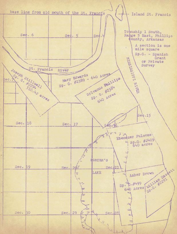
It is known that Sylvanus Phillips was living at the mouth of the St. Francis River as early as 1797, and that his neighbors were few in number.10 It is often claimed that he was the first white person to live in this area, with the exception perhaps of some transient French trappers. He came from North Carolina originally, by way of St. Louis, and down the river on a raft. Phillips was looking for the riches of the new lands, as was the host of settlers that followed him. In that same year, or shortly thereafter, Moses Burnett and Daniel Mooney settled on the St. Francis, along with William Patterson, and the latter person, together with Phillips, started a settlement called "Little Prairie" near the site of Old Helena.11
A good part of present day Phillips County was in the Spanish grants made to the Winter family. Later, Phillips bought land from them and others to whom the Spanish government had given grants and was confirmed in his claims by the United States government, In fact, Phillips, in partnership with William Russell, of St. Louis, who was perhaps the greatest land speculator of all times, bought land, sold it, rebought it, and sold it again. At one time, he and Russell owned most of what is now Helena, along with vast tracts elsewhere.
The year 1800 found more settlers on the St. Francis, namely, John Hogan, Edward Proctor, Joseph Sevier, Enos Chartreuse. By 1803, added to the St. Francis River settlements and on the Mississippi nearby, were John Taylor, John McLean, Jesse Stephens, William Gregory, Mary Edwards, Charles Stenson, Ebenezer Fulsome.
3
Between the White River and the St. Francis was Moses Perry, William Bailey was on Caney Creek, and in the near vicinity were Pat Cassidy, John Le Fevre, William H. Glass, and John Dill.12
William Patterson, previously mentioned, was an early settler in this part of Arkansas, and he may have preceded Phillips to the area. It is known that his son, John Patterson, was the first white child born in Arkansas of American parents, and later marriage records point to John Patterson's birth as having occurred in 1790. (The Historical Records Survey of the 1930's here in Helena lists his birthdate as June, 1800). It is said that John Patterson was born in an Indian village 5 miles north of Helena and that he could speak an Indian tongue as he grew up.
The opinion among older citizens in times past was that at the time John Patterson was born William Patterson was living at Big Prairie (also called Plum Orchard Point and Prairie Point) on Spanish Grant Numbered 499, which was approximately 5 miles north of Old Helena and 4 miles south of the mouth of the St. Francis River in 1817. The two names derived from the fact that the place was a natural prairie and in the center of the prairie was a wild plum orchard. Supposedly, the site of their home washed into the river. In later years, a large Indian burial ground was found there. This general area is also often called Quarles Island.
However, this story of where John Patterson was born is open to question, as Spanish Grant No. 499 was surveyed by Nicholas Rightor in 1817 for Asher Brown and did not belong to William Patterson. Most of the western part of Asher Brown's claim was in Porter's Lake, and when the survey was made in 1817 (some years after John Patterson's birth), there was no record of any improvements, orchards or fields in Spanish Grant No. 499.
Around 1800 or 1802, William Patterson cleared the cane and had a cottonfield and warehouse on Spanish Grant or Private Survey No. 2295. (in present day Helena this survey is bounded on the north by Elm Street, on the east by the Mississippi, on the south by Hanks Lane, and on the west by Don Street) The warehouse was used to store provisions for barge shipping and was perhaps Helena's first terminal. When William Russell surveyed this tract for William Patterson in February, 1816, he recorded that nearly the entire length of the claim on the Mississippi was cleared and improved, plus there being a number of houses and fields on the north line of the survey and on both Patterson's claim and the land which was later to be Old Helena. If Patterson had lived on the "Big Prairie", then this new settlement by him might quite
4
4a
naturally have been called "Little Prairie."
Early records of the Methodist Church in Arkansas tell that William Patterson was admitted to the Methodist Conference in 1804, so he was the first known preacher in these parts. These early records of the Church also state that the settlement of "Little Prairie" near the present site of Helena was destroyed by the New Madrid earthquake of 1811-1812.13 This fact does not seem to be recorded elsewhere in local records.
It would take far more settlers than these to make this part of Arkansas even remotely civilized. No protective levees existed and parts of the area along the riverbanks were true wilderness, It is known that Phillips, in 1799, along with the Pattersons and J. B. Mooney, moved for a few years to Arkansas Post, the reason being fear of an Indian uprising. (Phillips married one of Patterson's daughters, probably Phillips' first wife, during one of his stays at the Post). The Commandant of the Post of Arkansas had ordered them in to the Post, and the commandants of Spanish territory tried to keep the settlements in the general area of the post for security reasons.14
Another reason that Phillips moved to the Post was the fact that he had trouble with Spanish officials over his land holdings and trading rights on the Mississippi. Other citizens in this part of Arkansas went back and forth to the Post (at that time Arkansas Post was referred to as "Arkansas", the "Post" part of the name being added later), and many marriages among them were performed at the Post. Early settlers were given to wandering over bordering lands, and a considerable knowledge of this part of the state was gained in that manner. Phillips himself, while at Arkansas Post, made an extensive journey up the Arkansas River in search of gold mines and timber wealth.
Following the New Madrid earthquake of 1811-1812, settlers whose land was destroyed by the earthquake, often called "sunk lands", were allowed to take up public lands in the amount they had lost, and this brought many people into Arkansas. Another great colonization move was started with veterans of the War of 1812, to whom land grants had been made for their military service in place of cash returns. They came in great numbers to Arkansas, In 1810, there had been 1,062 People in Arkansas, while ten years later there were 14,273 people.15
2,000,000 acres in the State of Arkansas were set aside for military bounty lands. In 1815, a survey of the public lands west of the Mississippi was started, called the Purchase Survey, and this included the military bounty district between
5
the Arkansas and St. Francis Rivers. The rectangular system of surveying had recently been perfected and four principal meridians established. Therefore, their first task was to run a base line and the Fifth Principal Meridian.
The base line was to begin at the mouth of the St. Francis River and run due west, and on October 27, 1815, Joseph C. Brown, Deputy Surveyor, his chain carriers, Nathan Myers and Richard Sessams, and his marker, Nathan Gilpin, began their survey of the base line. The Fifth Principal Meridian begins at the mouth of the Arkansas River and runs due north, and on that same date, October 27, 1815, P. R. Robbins, Deputy Surveyor, and his chainmen, Alexander Baldridge and Hiram Scott, and his axman, John Baldridge, began their survey of this Meridian. The intersecting point, where the Principal Meridian crosses the base line (where present day Lee and Phillips Counties corner on the east line of Monroe County), was reached on November 10, 1815, and this point is the starting point for all surveys of land in the original Louisiana Purchase. A witness tree was marked, became unidentifiable for many years, and was rediscovered by surveyors T. M. Jacks and E. P. Douglass in 1922.
It was at this time that the town of Utica, said to have been at the mouth of the St. Francis River, flourished. It has been said that Utica was in existence as early as 1800, and had a population of around 100 people, but this is doubtful. At any rate, in 1817, a surveying district was set off for the lower St. Francis, and the town of Utica was booming as a result of that.
People were gathering at Utica, awaiting the results of the survey, and had in hand one or more of four different kinds of paper: old Spanish grants, military land warrants, New Madrid certificates, or certificates of purchase from the United States government, Utica was laid out as a town in 1817 by Nicholas Rightor,16 who had come out from New York state as a United States government surveyor in that same year. He probably gave the town its name, as Utica, New York, is located in the same part of the state from which he came.
At the time that Utica was flourishing, some reports say that the present site of Helena was a village named St. Francis. The early legislators were listed as from St. Francis. Utica existed until about 1820 or 1821, and then disappeared, along with another old town in that neighborhood called Shirley.17 Marriage records dating from the Utica of 1820 were available in later years. Whether or not the town washed into the river, as has been said, is not known.
Shinn's Pioneers gives an account of William B. R. Hornor (sic), who was one of the early leaders in St. Francis Township.
6
The following sketch is quoted from this book.
"One of the leaders of this settlement was W. B. R. Hornor. Sylvanus Phillips and Daniel Mooney came earlier, being there prior to 1800. In the death notice of Hornor it is stated that Hornor came in 1811 and that he was among the last of the earlier wave of settlement. But while Mooney and Phillips were earlier, they were no more prominent.
W. B. R. Hornor was born at Falmouth, Virginia, in 1785, of an old and respectable colonial family. He was twenty-six years of age when he landed at the St. Francis settlements in 1811, and was fifty-eight (sic) years of age at his death in Helena on May 11, 1838. He settled in this region before Phillips County was born and was the principal figure in its creation. He was before Helena was, and to him more than any other of the earlier men is Helena indebted for the vigor of her early existence. Hornor was a resident of the settlement when it was a part of Louisiana territory and saw that territory die; he lived in the settlement all through its life as a part of the territory of Missouri end all through the life of the territory of Arkansas.
He died just as Arkansas threw off the territorial yoke, and took place among the sisterhood of States. That Hornor was one of the quickening forces in all these changes can not be denied. . . . . He had the confidence of the St. Francis settlement, the Mississippi settlement and of the people at Arkansas Post."18
W. B. R. Hornor and Gen. W. O. Allen were elected as representatives for the first territorial legislature from Arkansas County (of which present day Phillips County was a part). At this time, Sylvanus Phillips was a member of the five man upper house, or Council, Hornor was instrumental in having Arkansas County divided and Phillips County created from a part of it on May 1, 1820, and he was also the representative from Phillips County in the third territorial legislature.19
Some of Hornor's other offices besides that of territorial legislator were prosecuting attorney for the First circuit, deputy clerk of Phillips County in 1820-1821, Common Pleas judge, 1821 (Daniel Mooney and Benjamin Fooy serving in the same capacity), land agent, postmaster at Helena in 1823-1825, alderman of Helena, 1828.20
W. B. R. Hornor had lived at Arkanses Post, at Utica and at St. Francis. He married Elizabeth Dunn, daughter of Phoebe Dunn, mentioned in the following paragraph. Besides holding the offices already mentioned, he kept a tavern in Helena as early as January, 1822.21 Beginning on June 23, 1821, the
7
Arkansas Gazette started referring to Col. Hornor and Col. Mooney as being from Helena, whereas previous to that time they had been named as being from St. Francis, which evidently the old village at the location of Helena had been called.
Another family of early settlers on the St. Francis was the family of Phoebe Dunn, a widow. Following the New Madrid earthquake, she and her family moved from the "sunk lands" and settled at Utica, having been granted a New Madrid certificate. The Dunn family papers give the same reason for the briskness of business at Utica at that time, that people clustered there to get first choice of the newly surveyed lands. These family papers place Utica west of the mouth of the St. Francis River on Crowley's Ridge. Phoebe Dunn married William Patterson in 1815, and the family papers refer to Patterson as being of Caney Creek. The writer and collector of the papers, Joseph S. Dunn, remembered "Uncle Johnny" Patterson well, and said that Uncle Johnny had often visited at his father's home.
Phillips County was created in 1820 and was surveyed in large part by William Russell, It was much larger than the present county, including in the beginning part or all of what are Crittenden, St. Francis, Monroe, Mississippi, Poinsett, Cross, Woodruff, Craighead, Lee, and Arkansas Counties.
In December, 1820, Nicholas Rightor laid out the town of Helena, approximately one mile square. A recent event, the War of 1812-1815, was perhaps reflected in some of the street names, naval Captains Porter, Perry and MacDonough having been heroes of that war, and the Battle of York (Toronto) an American victory, Nicholas Rightor's original map is in the Phillips County Museum.
When Phillips County was created, the "Town of Monticello” was named as the first county seat. The exact location of Monticello remains a mystery. Some older citizens in times past tried to locate it, and ended with placing it at the site of Helena. This does not seem possible if Helena was laid out in 1820 and the previous village here was called St. Francis. Did Helena and Monticello exist independently? Monticello remained the county seat until 1830, when Helena gained that position. One theory is that Helena, Monticello and St. Francis were one and the same, but, if so, there was certainly a great profusion of names for the same small settlement. It has also been said that Monticello washed into the river. But where was Monticello, the county seat, in the year 1824, with the reference from the following tax deed to the "courthouse door at Helena"? (This deed is part of the Burke family papers).
"This Indenture, made this 22nd day of November in the year of our Lord one thousand eight hundred and thirty one between
8
8a
Henry L. Biscoe, Sheriff of the County of Phillips in the Territory of Arkansas, and Collector of the taxes therein, of the one part; and Benjamin Burress of the same county and territory, of the other part, WITNESSETH, that, whereas, by an act of the Congress of the United States, passed the 2nd day of March, 1819, entitled "An act establishing a separate Territorial government in the southern part of the Territory of Missouri," power is granted to the General Assembly of the Territory of Arkansas, to levy a tax on bounty lands, situated in said Territory, granted for military services during the late war, after the expiration of three years from the date of the patent, and, also, on all other lands, in said Territory, whether owned by residents or non-residents; and whereas, pursuant to said authority, the General Assembly of said Territory of Arkansas have enacted laws, imposing a yearly tax of one dollar and fifty cents upon every one hundred acres of confirmed land, lying in said Territory, and made it the duty of the Sheriffs of the several counties therein, to advertise, by giving sixty days' previous notice, in some newspaper printed in said Territory, and sell, at public auction, in each and every year, all lands, subject to taxation, lying in their respective counties, which shall have been listed and entered for taxation, according to law, and on which the taxes imposed thereon, shall not have been paid, agreeably to the laws imposing said taxes, and regulating the collection thereof; and whereas, the following tract of land, viz: the Northeast quarter of Section ten, of township one south, in range four of the 5th principal Meridian, containing one hundred and sixty acres, lying in the said county of Phillips in the territory aforesaid, and patented to Henry Speck was, among other lands, entered and listed for taxation, in said county,"...."Therefore, Daniel Mooney, the late and then Sheriff of the said County of Phillips did proceed to advertise and give at least sixty days' previous notice, according to law, that he would sell, at public auction, on Monday, the eighth day of November, (being the - Monday of said month), in the year 1824, AT THE COURT-HOUSE DOOR, IN THE TOWN OF HELENA IN THE SAID COUNTY OF PHILLIPS" .....
Sylvanus Phillips had returned here permanently from Arkansas Post in 1819, and his house was located where the First Baptist Church of Helena is now, and where Fort Curtis stood during the Civil War. The ground there was much higher than it is now, and his home and the lend surrounding it was known as the "Hill Place."22 At one time a painting of this cabin existed. The cabin was drawn on the map by Nicholas Rightor and is easily discerned now.
Phillips County was named for the old settler and the town of Helena for his daughter. Sylvanus Phillips and Helena Phillips both died in 1830 and were buried in the same grave. This grave supposedly was on the "hillslope", or Graveyard Hill, and had a
9
prominent marker. Following the Battle of Helena, there were plans to move some of these early remains, but it was not done, and the sites of the graves that were not demolished during the fighting were forgotten. It was also planned to mark the site of Phillips' cabin at one time.
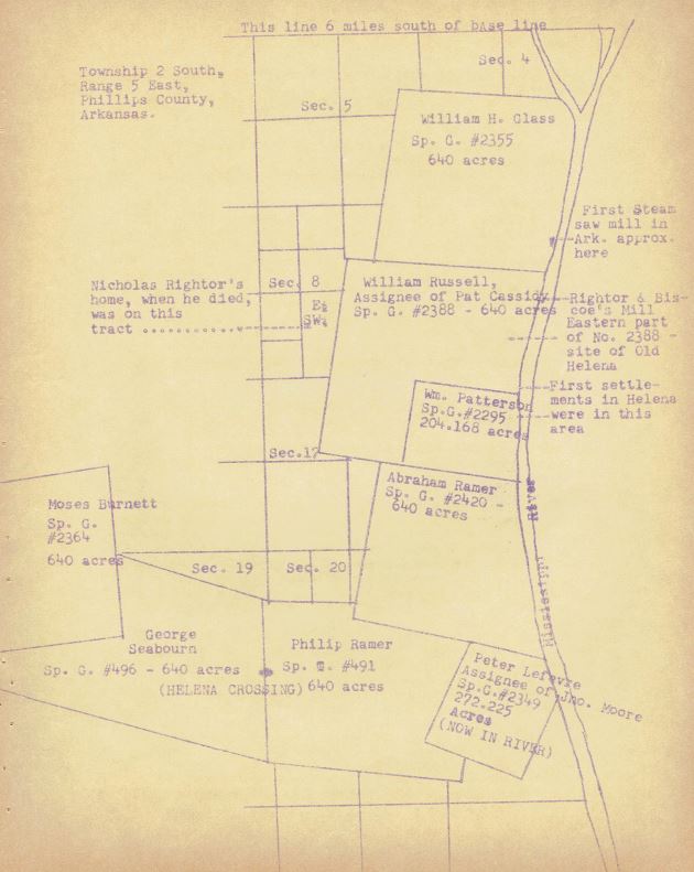
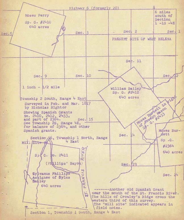
When Helena was laid out, the lands on which it was planned belonged to Phillips and William Russell. Most of this land seems to have been spoken for during the Spanish regime. The United States government had confirmed these claims, after surveys were made, and gradually given patents to the holders. None of the old settlers were Spanish but originally they had taken the oath of allegiance to Spain, as required. Some of the original holdings were by William H. Glass, Private Survey or Spanish Grant No. 2355, 640 acres north of present Walker Street; William Russell, as assignee of Pat Cassidy, P. S. No. 2388, 640 acres, embracing all of "Old Helena" and from the river to present part of Oakland Avenue; William Patterson, P. S. No, 2295, 204.16 acres embracing the "Middle Addition" and "New Helena", from the river to Don Street and from Elm Street to Hanks Lane; Abraham Ramer, P. S. No. 2420, 640 acres, embracing the Hanks, Straub, Lohmenn, and Coolidge holdings; Philip Ramer, P. S. No. 491, 640 acres in the old Williamson, now Solomon, Place; Peter Le Fevre, as assignee of John Moore, P. S. #2349, 272.22 acres, caved off into the river on the Solomon Place; George Seabourn, P. S. No. 496, 640 acres, the old Lamb Place at the Helena Crossing; Moses Burnett, P. S. No. 2364, 640 acres of the E. D. Pillow-Airey Place, the Hanks Place, and the old Calvert Place; Moses Burnett for Joseph Mason, P. S. No. 2433, 272.22 acres, containing the old Hanley Place and J. J. Porter Place; William Bailey, P. S. No. 2412, 640 acres, containing the Moore Bros., Rufus Polk, part of Coolidge and J. B. Pillow places on Caney Creek; Moses Perry, P. S. 2410, 640 acres, on which were the old Cad L. Polk home place and the old Wm. M. Lowery home place.
The town that was laid out in 1820 on a part of Spanish Grant or Private Survey No. 2388 was "Old Helena," bounded by the river on the east, "Back Alley" on the west (west of College Street), on the south by Elm Street, and on the north by the "Porter tract" and the old Rightor House. In 1836, wheat is known as New Helena was laid out, bounded on east by the river, on the west by Don Street, and extending from Missouri to Louisiana Street. In 1854, the Middle Addition to Helena was laid out, consisting of lots between the river and Columbia Street, and between Elm and Missouri Streets.
Helena was incorporated es a town in 1833, In 1856, New Helena, the Old Town of Helena, and the Middle Addition to Helena were incorporated as a city. There was a lot of excitement and people came for miles around, from the farms and the
10
10a
woods, to attend the celebration.
When Helena was first organized, the organization was mostly on paper, with only a few streets open and a few cleared areas. People lived on the farms and came into town for supplies. Much trading was done directly with the river boats, with a few businesses existing on the main street, named Water Street on the map of Old Helena, but often called Front Street, which later washed into the river. Ohio Street was the main residential street, and Sylvanus Phillips was probably considered to be living in the woods, away over on Franklin Street. The Bowie house, in 1831, was the first brick house in Helena, and the only one. The first steam sawmill started cutting lumber at Helena in 1826, and was built and run by Benjamin A. Porter and George King on the Mississippi just north of Walker Street.
Some well-known names in Helena of the 1820's and 1830's, besides those already mentioned, were Griswold Latimer, Darby Pentecost, William K. Sebastian, Silas Drury, W. W. Palmer, Robert Maloney, William P. Craig, Miller Irvin, Thomas B. Hanley, Davis Thompson, Thomas J. Lacy, James H. McKenzie, William M. McPherson, S. C. Mooney, S. R. Sumpter, Benjamin T. Odle, William Dodson, Fleetwood Hanks, J. R. Sanford, Ferdinand S. Hornor, William F. Moore, John Swan.23 When Helena was incorporated in 1856, some of the oldtimers who were still around for the celebration were Henry L. Biscoe, Thomas B. Hanley, Boyd Bailey, Darby Pentecost, Fleetwood Hanks.
On early maps, Arkansas was first shown as a geographical division on the Lewis map, with one town noted, named Delaware, on the White River. The Nelish map of 1816 showed no towns, while the Varle map, 1817, shows Arkansas Post and Lawrence. Some early maps, names unknown, showed the town called St. Francis located at the present site of Helena. On Watson's map, 1820, Helena was called St. Helena and was located about 10 miles south of present day Helena. On the Brown and Bancroft map of 1825, 13 counties were shown and also Helena, which the map called St. Helena end placed in the correct location.24 Maybe Napoleon's incarceration on the island of St. Helena in the early 1820's confused the mapmakers when they wrote the name "Helena" on the map of Arkansas. Letters of the 1840's in the Burke family papers are addressed to "St. Helena, Ark."
In a letter of April, 1826, recommending Col. Sylvanus Phillips as agent for Indian affairs at Helena, to help solve the problem of getting them across the Mississippi River and on through Arkansas, Helena is called St. Helena.25 The same name is used in Volume XXI of the Territorial Papers,26 and Helena is also spelled Hellenna in this collection.27
11
Some interesting facts about early Helena are found in letters written by the late Mrs. Belle McKenzie, in answer to questions asked by Miss Anna Vineyard for a possible history of Phillips County. Mrs. McKenzie was the daughter of Angelina Hartin Howard and William Irving Howard, and these letters contain bits of history told her by her mother.
Mrs. McKenzie states that the Bowie house was the first brick house in Helena and was the only one when her mother came here in 1831. It faced the river and was near Market Street. It was well preserved when torn down some years prior to 1917 (date of this letter), she supposed to make room for the levee.
When Mrs. Howard came to Helena, Drs. Deputy and Odell were practicing here. The Drs. Grant came later and were brothers, Dr. Hargraves came in the early 1840's, did not practice medicine, but kept a livery stable. The Thompsons were early settlers and lived in the northern part of what is now the cemetery (Maple Hill). William F. Moore came down in a flat-bottomed boat about 1832 or 1833.
Mrs. McKenzie did not think there was a church here in 1831, but services were held in homes, under arbors and occasionally there were camp meetings. Mail delivery was by horse and stage, with 25¢ postage on a letter. Letters were as rare as the visits of angels to earth.
The old Military Road was very important to Helena and almost broke the State's treasury to build it. Murrell's bunch killed and plundered in this area, Indians passed through here to the Western Reservation, which took many days. Judge John S. Hornor taught school for a few years in a little log cabin higher up on Ohio Street from Mrs. McKenzie's home, which was on the southwest corner of Miller and Ohio Streets.
Her letters say that Mr. Cossitt who gave the library to Memphis was an early merchant here.28 He later went to Memphis and then to New York City, where he became wealthy..... The "General Brown" was a fine new boat starting her first voyage south (no date given). She landed at Helena and several Helenians went aboard to look at her when the boilers exploded, killing most of them, the Captain, and many passengers, and fatally scalding others. A history of the disaster could almost be read on the monuments in the cemetery.
Library papers tell of how, in the 1850's, the Reverend Otis Hackett of the Episcopal Church here was in the habit of visiting his parishioners at Old Town. He visited John R. Williams at Piney Grove, then came on around Old Town Lake to the Wards, Higgins, and Scandlins. In going to Old Town and around Old Town Lake back to Helena, he traveled a distance of
12
45 miles.
The main street of Helena was Water Street. Scrapbooks at the Helena Public Library state that 3 or 4 foot levees began to appear around 1850 in this area, According to this same source, Water Street went into the river shortly after 1867.
1John W. Monette, The Valley of the Mississippi, Volume I, (Harper & Brother, Publishers, 1846), p. 50.
2Fred W. Allsopp, Folklore of Romantic Arkansas, Volume I, (The Grolier Society, 1931), p. 116.
3Walter L. Brown, Our Arkansas, (Austin, Texas: The Steck Co., 1958), p. 34.
4Ibid, p. 55
5Ibid, p. 117
6Arkansas Democrat, Arkansas Centennial Edition, Little Rock: June 14, 1936, p. 8
7Ibid, p. 10
8Brown, pp. 67-68
9Ibid, pp. 103-104
10Josiah H. Shinn, Pioneers and Makers of Arkansas, (Little Rock: Genealogical and Historical Publishing Co., 1908), p. 26
David Y. Thomas (ed.), Arkansas and Its People; A History 1541-1930, Bol. II, (The American Historical Society, Inc., New York, 1930), pp. 754-755.
11Arkansas Democrat, p. 9.
12Shinn, pp. 42-43.
13James A. Anderson, Centennial History of Arkansas Methodism, 1815-1935 (L. B. White Printing Co. Benton, Ark. 1935), p. 41
14Clarence E. Carter (ed.), The Territorial Papers of the U. S. Vol, XXI, The Territory of Arkansas, 1829-1836 (Washington: U. S. Government Printing Office, 1953), p. 76
15Brown, pp. 79-80
13
16Deed Record Book "A"', p, 207, Official records of Phillips County.
17Shinn, pp. 119-120
18Ibid, p. 120. Hornor also had a residence at the town of Rome, which was about 5 miles from Arkansas Post, Rome lasted from about 1819 to 1829, The reasons for its beginnings was to get to high enough ground (unlike Ark. Post) so that during the overflows of the Arkansas River it would be ratproof. Ark. Post was overrun with them. Land title trouble brought an end to Rome. Shinn, p. 83.
19Ibid, pp. 122-124
20Ibid, p. 123
21Circuit Record Book "A", p, 28, official records of Phillips County. He paid a tax of $10 for the privilege.
22Deed Record Book "F", p. 312, official records of Phillips County, Phillips' widow, Rebecca, married John Burriss, and on May 14, 1841, deeded to Caroline Phillips Hanly, his daughter: Lots 326 and 382, Old Helena, "being the same upon which the late Sylvanus Phillips resided at the time of his death and commonly known as the "Hill place," Phillips' cabin is shown to be on the southeast corner of the intersection of Perry Street and Broad Alley, on Lot 326, there being only two lots in the entire block.
23Shinn, pp. 128-130.
24Ibid, p. 148
25Territorial Papers of the U. S., Vol. XX, p. 225.
26Territorial Papers of the U. S., Vol. XXI, p. 1048
27Ibid, p. 1320
28In the June 9, 1836, issure of the Constitutional Journal, Helena, Arkansas (printed and published weekly by William T. Yeomans) appears an advertisement by Fredk. H. Cossitt wherein he states that having located himself in this place he is now opening "at the store house lately occupied by Messrs. Lurty & Bowie" a new store with a splendid assortment of staple & fancy dry goods, hardware, Queensware, &c. The ad lists various dry goods, ready made clothing, jewelry, hats, boots, shoes, saddles, bridles, etc.
14
ABSTRACT OF EARLY MARRIAGE RECORDS OF PHILLPS COUNTY
***
Marriage Record Book "A", containing records of the earliest marriages recorded in Phillips County, is now missing from the office of the County Clerk, and the following is from the Index of Marriage Records Book 1, which shows only the names of the two parties and the marriage record book and page on which the certificate was recorded. The only change we have made is to insert a comma following the surname of the bridegroom, and to number the entries. There were 143 marriages recorded in this book and we intend to list all of them and to make this a continuing feature in the Quarterly. You will note that many of these names are spelled phonetically. We are listing them exactly as they are shown, but a question mark following the name indicates we are uncertain of our translation.
***
| 1 | Anderson, Thomas to Polly Lane | Book "A", | page 10 |
| 2 | Adams, Thomas to Rachael White | Book "A", | page 36 |
| 3 | Biscoe, Henry L. to Phebe C. Carpenter | Book "A", | page 20 |
| 4 | Burress, John to Sallie Cooper | Book "A", | page 22 |
| 5 | Bailey, Boyd to Roseanne McGarnigle | Book "A", | page 34 |
| 6 | Berret, Elijah to Sarah Gittings | Book "A", | page 41 |
| 7 | Brigance, Alfred to Lydia Ann King | Book "A", | page 51 |
| 8 | Burress, John M. to Augusta Loomis | Book "A", | page 58 |
| 9 | Campbell, John to Elender Campbell | Book "A", | page 9 |
| 10 | Chambers, Jerry to Elvy Barton | Book "A", | page 11 |
| 11 | Carson, Samuel to Drucilla Richardson | Book "A", | page 17 |
| 12 | Clayton, James to Malinda Williams | Book "A", | page 18 |
| 13 | Courtney, James to Loucreasy Wilson | Book "A", | page 20 |
| 14 | Council, Simion? to Rebecca Lean | Book "A", | page 27 |
| 15 | Carothers, John to Lavina Slankard | Book "A", | page 29 |
| 16 | Clary, Urial A. to Adelia Latimore | Book "A", | page 34 |
| 17 | Campbell, William to Delia Hampton | Book "A", | page 37 |
| 18 | Connell, Robert S. to Lucy Ann Goings | Book "A", | page 40 |
| 19 | Crisa, Phillip to Ann Wolf | Book "A", | page 43 |
| 20 | Clark, Edwin T. to Harriet Sanford | Book "A", | page 50 |
| 21 | Duke, John to Sarah Dickson | Book "A", | page 8 |
| 22 | Dunn, Hiram to Patsey Hensley | Book "A", | page 9 |
| 23 | Dunn, William to Sally Murch | Book "A", | page 10 |
| 24 | Duke, Major to Elizabeth McLain | Book "A", | page 15 |
| 25 | Drury, Silas to Eliza J. Oakley | Book "A", | page 17 |
| 26 | Dunn, Samuel to Mary McCally | Book "A", | page 19 |
| 27 | Dye, John K. to Amelia Peyburn | Book "A", | page 26 |
| 28 | Dunn, Gideon to Hesther Stanford | Book "A", | page 27 |
15
| 29 | Davis, Hiram to Sallie Standlee | Book "A", | page 28 |
| 30 | Drusmusky ? , Andrew to Polly Ann Spira | Book "A", | page 34 |
| 31 | Deen, William to Nancy Mullins | Book "A", | page 35 |
| 32 | Devant, William to Mary Ann Hancock | Book "A", | page 43 |
| 33 | Dozan, Alexander to Elizabeth Pledger | Book "A", | page 44 |
| 34 | East, Isaac to Jerushe Turner | Book "A", | page 3 |
| 35 | Enos, William to Elizabeth Mandle | Book "A", | page 9 |
| 36 | Edwards, Peter to Elinnia ? F. Hornor | Book "A", | page 23 |
| 37 | Ferguson, Champion to Margaret Hamlin | Book "A", | page 11 |
| 38 | Fogle, George to Sally Baleman | Book "A", | page 12 |
| 39 | Fisher, Jackson to Jane Douglas | Book "A", | page 17 |
| 40 | Franks, Chesley to Jerusha May | Book "A", | page 18 |
| 41 | Forbes, James to Rachell Frank | Book "A", | page 29 |
| 42 | Franks, Elisha to Boreshiba Gervis | Book "A", | page 30 |
| 43 | Flanders, Simon to Elizabeth Boone | Book "A", | page 39 |
| 44 | Fisk, James to Nancy Evans | Book "A", | page 46 |
| 45 | Fisher, Arnold to Polly Seaburn | Book "A", | page 56 |
| 46 | Gording, Abrahem to Fanny Jacobs | Book "A", | page 26 |
| 47 | Goings, Henry to Margaret Seaburn | Book "A", | page 40 |
| 48 | Garrison, Thomas to Elizabeth Hudson | Book "A", | page 48 |
| 49 | Hampton, Henry to Rhody Daniels | Book "A", | page 4 |
| 50 | Hicks, Joshua to Umilky " Tyre | Book "A", | page 7 |
| 51 | Hamblin, Elisie ? to Nancy Mitchell | Book "A", | page 11 |
| 52 | Hart, John K. to Harriet Burress | Book "A", | page 22 |
| 53 | Holly, Davis to Elmira Jacobs | Book "A", | page 22 |
| 54 | Houston, Aaron to Rebecca Robinet | Book "A", | page 28 |
| 55 | Hanks, James to Elizabeth Williams | Book "A", | page 30 |
| 56 | Hill, John to Mary Ballinor | Book "A", | page 32 |
| 57 | Hinson, William to Ruth Rollison | Book "A", | page 33 |
| 58 | Hanks, Fleetwood to Francis Sanford | Book "A", | page 37 |
| 59 | Hough, Wm. H. to Nancy Dukes | Book "A", | page 44 |
| 60 | Howard, John to Elizabeth Edwards | Book "A", | page 46 |
| 61 | Hann, Jonathan to Temperance Dunn | Book "A", | page 52 |
| 62 | Harris, Love M. to Frances Burress | Book "A", | page 57 |
(to be continued)
Abstracted by Mary Alice Sanders
Note: Recording began in Phillips County on January 1, 1821, and the next marriage record book begins on February 21, 1832. Thus, it is evident that Marriage Record Book "A" must have covered the period beginning January 1, 1821 to February 21, 1832. Records show, for instance, that Fleetwood Hanks married Francis Sanford (see No. 58 above) in 1827.
16
STREET NUMBERS
From Helena City Directory, 1909
CHERRY STREET Main thoroughfare, running from Missouri north to Limits
| s end St | L I M & S ry | 317 | Graham & White D G Co |
| Arkansas Midlend Ry | 318 | Ehrman Bro | |
| M H L R R | 319-21 | Truemper | |
| 20 | W W Hartung Saloon | 320 | Gates & Co |
| 101 | M H Flanders Saloon | 322 | Noland's Barber Shop |
| 105 | Noland & Jamison | 322 | F W Haury |
| 119 | J W Hutson | 323 | Fink & Halpern Dry Goods |
| 131 | Black Diamond Drug Store | 323 1/2 | Dr H H Rightor |
| 133 | Tanner & Co | 324 | Silver Moon Hotel & Cafe |
| 141 | A Peters | 325 | Wooten Davidson & Co |
| 143 | Ben Wiley Gro Co | 326 | Mitchell Bros |
| 145 | F C Coldwell (c) | 327 | S L Mundt Dry Goods |
| 201 | N Straub & Son Gro Co | 328 | LW Ellis |
| 201 1/2 | Dr N B Houser (c) | 328 1/2 | Lee Pendergrass Cotton Co |
| 203 | H Becker Dry Goods | 329 | J Bielson Jewelry Co |
| 207 | Palace Scloon | 330 | Peoples Saving Bank & Trust Co |
| 209-11 | Wenzel House Furn Co | 401 | Altmon Bros Dry Goods Co |
| 211 1/2 | Miller's Hotel | 401 1/2 | Chas Miller dentist |
| 213 | New South Saloon | Jno Ike Moore | |
| 213 | Mississippi Saloon | J Vineyerd | |
| 217.5 | J C Clopton & H Coolidge | 402 | First National Bank |
| 217-19-21 | Ark & Miss Hdw Co | 402 1/2 | Helena Water Co |
| 223 | Miller's Cafe | Aaron Meyers & Son Ins Co | |
| 225 | Smith Furniture Co | J C Jeffries | |
| 227-29 | Rosenberg Dry Goods Co | 403 | Benner Gro Co |
| 229 1/2 | Helena Cotton Co | 404 | Helena Liquor Co |
| 231-233 | J B Butts & Co | 405 | S Simon Gents Fur Co |
| 234 | Y M & V R R Depot | 406-08-10 | Tappan Hardware Co |
| (passenger and freight) | 407 | A Bell Co | |
| 235 | Red Cross Drug Store | 409 | B & B Annex |
| 300-304 | Solomon & Johnson Gro Co | 411 | Hallel & Nakel |
| 301 | Solomon & Hopkins | Ciener the Cleaner | |
| 303 | W W Dinning 10¢ Store | 412 | H M Hutson |
| 303 1/2 | Drs Cox & Cox | 413 | C L Moore Dry Goods Co |
| Chas Wooten | 414-18 | Ware & Solomon Dry Gds | |
| 305 | Altman Liquor Co | 415-17 | Helena Hardware Co |
| 306 | Saunders & Hartung | 419 | Jiedel & Rothschild Dry Goods |
| 307 | Meyers Furniture Co | 421 | Lieber Dry Goods Co |
| 308 | Ike Kline Dry Goods | 422 | Shield Office |
| 308 1/2 | McDonald Bros Lumber Co | Western Union Tel Co | |
| 309 | A Cottem | 423 | B M Isaacs Dry Goods Co |
| 310 | Wood Drug Co | 424 1/2 | Dr M Dryer Dentist |
| 311-13-15 | C L Moore Co Gro | 424 | White Palace Meat Market |
| 314-16 | D T Hargraves & Co | 425 | Crescent Jewelry Co |
| 316 1/2 | J A Short & Co | 427 | Solomon Sho Store |
| Reeves Short & Co | 427 1/2 | Dr W C Russwurm | |
| C H Friberg | R Chew |
17
CHERRY STREET, continued
| 427 1/2 | Dr Britt Dentist | ||
| J B Miles | 912 | Mr & Mrs W L Jarman | |
| Bevens & Mundt | 915 | Mr & Mrs Bell | |
| G Blackwood | 916 | Mr & Mrs S D Carter | |
| 429 | Interstate Bank & Trust Co | 926 | Mr & Mrs Will Cunningham |
| 501 | B J Bruen & Co | 927 | P Perkins & wife (c) |
| 501 1/2 | Fink & Dinning Lawyers | 1001 | Mr & Mrs Hugh Martin |
| 503-5 | Hornor & Co Gro | 1009 | Mrs A W Sutherland |
| 507 | Bank of Helena | 1019 | Dr R A Williams & wife (c) |
| 508 | W W Anderson Ins Co | 1020 | Mr & Mrs Gunn |
| 510 | Sam Solomon | 1022 | Mr & Mrs Altman |
| 511 | Model Pharmacy | 1117 | Mr & Mrs H G Rightor |
| 512 | Helena Tin & Plumbing Co | ||
| 512 1/2 | Wooten & Co | ||
| 513 | Idle Hour Theatre | ||
| 514 | Bowling Alley | ||
| 515 | Smoke House | ||
| 517-19 | Habib Etoch Restaurant | ||
| 520 | Helena Gas & Light Co | ||
| 521 | Palace Barber Shop | ||
| 522 | F A Dauer | ||
| 523 | B L Lyford | ||
| 524 | Cleburne Barber Shop | ||
| 525 | Windsor Barber Shop | ||
| 526 | Cleburne Hotel | ||
| 527 | B J Cunningham | ||
| 528 | Smoker | ||
| 529 | Palace Drug Store | ||
| 530 | Cherry Hall | ||
| ne Porter & Cherry - Post Office | |||
| 601 | City Bakery | ||
| 601 1/2 | Cleburne Annex | ||
| 603-27 | Pillow's Livery Stable | ||
| 629 | Chinese Laundry | ||
| 704 | Mr & Mrs, J A Jamison | ||
| 707 | J H Krickle Shop | ||
| 708 | Mr & Mrs B J Cunningham | ||
| 711 | Mr & Mrs A Cottem | ||
| 720 | Mrs L Ford | ||
| 728 | Mr & Mrs J Etoch | ||
| 729 | Mr & Mrs C H Back | ||
| 803 | Mr & Mrs Geo Zambie | ||
| 809 | Mr & Mrs H Etoch | ||
| 817 | Mr & Mrs H V Thompson | ||
| 818 | Mrs H D Woods | ||
| 821 | Mr & Mrs R Word | ||
18
BEECH STREET, 5th street west of Cherry from Phillips north to limits,
| 206 | Mr & Mrs W D Reeves | 615 | Mr & Mrs J Crenshaw |
| 214 | Mr & Mrs M J Neely | 621 | Mr & Mrs D C Shanks |
| 216 | Mr & Mrs R Harrington | 626 | A Hobdy (c) |
| 228 | Mr & Mrs A R Govan | 627 | Magnolia Meat Market |
| 229 | Mr & Mrs M E West | 628 | Mr & Mrs L A Lincoln |
| 303 | Mr & Mrs Wm McCoy | 629 | Magnolia Gro Co |
| 306 | A Miller & wife (c) | 701 | West End Gro Co |
| 314 | Delphenia Herrod (c) | 707 | Mrs M Cook |
| 323 | Mr & Mrs R C Moore | 709 | Mrs I Lieber |
| 416 | Anne Martin (c) | 729 | Mr & Mrs H S Hornor |
| 418 | Annie King (c) | 802 | Mr & Mrs Walter Brady |
| 427 | Mr & Mrs B J Bass | 803 | Mr & Mrs J B Lambert |
| 504 | Mr & Mrs E Graham | 804 | Mr & Mrs Sam Solomon |
| 507 | A Peoples & wife (c) | 813 | Mr & Mrs J Powell |
| 513 | Melinda Brown (c) | 816 | Mr & Mrs H Hopkins |
| 514 | Mr & Mrs E P Goven | 825 | Mr Leon Barton |
| 518 | Mr & Mrs Jno Quarles | 826 | Mr & Mrs F F Kitchens |
| 519 | Mr & Mrs E Newman | 906 | Mr & Mrs T J Mitchell |
| 523 | Mr & Mrs A Johnson | 913 | Mr & Mrs L S Powell |
| 527 | Mr & Mrs I Fink | 916 | Mr & Mrs Cage Rembert |
| 609 | Mr & Mrs C Quarles | 928 | Mr & Mrs C H Purvis |
COLLEGE STREET, 7th street west of Cherry from York north to limits.
| 423 | Dr & Mrs Frierson Moore | 913 | Sarah Miller (c) |
| 428 | Mr & Mrs J P Moore Jr | 917 | N Lewis & wife (c) |
| 509 | Mr & Mrs J C Tanner | 921 | A Greer & wife (c) |
| 512 | Susie Frierson (c) | 923 | J L Alston (c) |
| 514 | Annie Webb (c) | 1003 | S L Daily & wife |
| 523 | Mr & Mrs J Bookhart | 1014 | V Murry & wife |
| 613 | N C Nixon (c) | 1015 | Wm Franklin & wife (c) |
| 632 | Emma Parker (c) | 1018 | Adeline Collins (c) |
| 701 | Caroline Guest (c) | 1027 | Mr & Mrs C N Underwood |
| 729 | Mr & Mrs G Yaeger | 1101 | Mary Loony (c) |
| 806 | Mr & Mrs M L Stephenson | 1103 | Julia Thomas (c) |
| 810 | Mrs S A Sanders | 1115 | Mr & Mrs F Simon |
| 824 | Mr & Mrs A N Tanner | 1117 | J Davis & wife (c) |
| 827 | Mr & Mrs E S Scott | 1119 | E McGahey & wife (c) |
| 830 | Mrs G Phillips | 1121 | P Johnson (c) |
| 909 | Ed Lawrence (c) | 1125 | Geo White & wife (c) |
19
OHIO STREET, 1st street east of Cherry from Elm north to limits
| 120 | Ora White (c) | 609 | Lyle Bros |
| 202 | S Price & wife (c) | 611 | Lyford's Steam Laundry |
| 219 | Josie Petiford (c) | 615 | H Carvill Lumber Co |
| 317 | John Murry (c) | 630 | Ester Eli (c) |
| 319 | Maria White (c) | 701 | J O Bagwell |
| 323 | J O Newby | 704 | Mr & Mrs W J Cunningham |
| 411 | Richard Waller (c) | 707 | Mr & Mrs H Bickley |
| 425 | A D Herron (c) | 708 | Mr & Mrs G Rose |
| 427 | Paul Bulow Novelty Works | 715 | Mr & Mrs E Levy |
| 429 | J P Moore Office | 729 | Mr & Mrs J L Solomon |
| 500 | Triumph Warehouse | 803 | Dr & Mrs J Mitchell |
| 502 | Armour & Co | 815 | Mrs W L Nelson |
| 503 | Helena Job ‘Works | 816 | Mrs Williams |
| 505 | Fitzpatrick Drug Co | 827 | Mrs Belle McKenzie |
| 507 | W G Grimes (c) | 905 | Mr & Mrs E D Ehrman |
| 511 | W J & E M Polk | 910 | Mrs I Frank |
| 512 | Cohn Fruit Store | 915 | Mr J C Barlow |
| 513 | S D Warfield Gro Co | Mr & Mrs A Coolidge | |
| 514 | Words Steam Laundry | 916 | Mr & Mrs R L Kimbrough |
| 515 | Rogers & Co | 927 | Lotus Club Rooms |
| 515 1/2 | R C Burke | 1003 | Mr & Mrs S D Warfield |
| 520 | The Helena Daily World | 1004 | Mr & Mrs Pursley |
| 524 | Jas Loveland | 1006 | Mr & Mrs Heryford |
| 525-27 | Policastro Steam Carbonating | 1009 | Mr & Mrs J Hiiggins Jr |
| Co Floyd propr | 1018 | Mr & Mrs M Prewitt | |
| 601 | Southern Plumbing & Heating | 1024 | D F Rabb |
| Co | 1027 | Mrs L A Kane | |
| 601 1/2 | R W Nicholls | 1028 | Mr & Mrs Cardwell |
| S Wassell | 1103 | Mr & Mrs N A Wright | |
| 604 | Newmen Ice & Coal Co | 1130 | Mr & Mrs W R Porter |
| Mrs G J Sanford |
20
HISTORY OF THE FIRST METHODIST EPISCOPAL CHURCH, SOUTH, OF HELENA, ARKANSAS
by
Carolyn H. Curtis
***
This paper given before the Phillips County Historical Society on April 26, 1964; New material subsequently added.
***
The history of the First Methodist Church in Helena dates back to the early days of the city, for William Patterson preached as a local preacher at the settlement on the Mississippi River south of Elm Street before he was admitted into the Western Conference of the Methodist Church in 1804. This was perhaps the first appearance of Methodism in Arkansas Territory. In 1818 William Harrison Bailey opened his home for prayer meetings, and out of this grew the Society of Methodists of Helena.
The Town of Helena was laid out in December, 1820, and the records of the church show that the Reverend Benjamin Burress was preaching in Helena as early as 1822. In 1823 or 1824 a society of Methodists was organized by local preachers, and it is probable they filled the pulpit until about 1830. In 1830 the church was made a part of a Circuit and supplied with regular pastors end presiding elders.
John Harrell tells the story of a trip through Helena in December, 1831, by a group of eight preachers assigned by the Missouri Conference to fill the Arkansas District.
"We left Memphis on the 25th of December, 1831...... We arrived at Helena on the evening of the third day. The river had fallen suddenly, making it very difficult to gain the bank with our horses; but we succeeded and reached the hotel. After breakfast next day, our bills paid, Brother Smith asked the landlord to let him pray with his family. The answer was, "I do my own praying." This was our introduction to our new field of labor.
"Traveling west a few miles, we reached the house of a Brother Burriss, a good and useful local preacher who had settled in the canebrake with a large family, most of whom were daughters; but they were cheerful and happy, and their hospitality was truly pleasant to enjoy. Here we met Brother Fountain Brown, who has been sent over to cultivate this wild and unsettled land....."
The pastors from 1830 to 1848 were: John Harris, 1830-1831; Fountain Brown, 1831; Michael Casteel, 1833; J. R. Neill, 1834; S. Wakelee, 1835; J. R. Rieves. 1836, in which year the Arkansas
21
Conference was organized, including the church of Helena; J. L. Newman, 1837; Spencer Walters, 1838; Wm. B. Mason, 1839; J. M. Steel, 1840-1841; L. Freeman, 1842; R. R. Burts, 1843; C. H. Edwards, 1844-45; W. P. Ratcliffe, 1846; G. W. Cottingham, 1847; W. F. Ratcliffe, 1848.
The presiding elders during this period were: Uriel How, Jesse Green, Andrew D. Smith, M. Wells, Chas. J. Ramsey, C. J. Karney, J. C. Parker, W. P. Ratcliffe, G. W. Morris, J. F. Truslow, Fountain Brown and J. M. Steel.
In 1848, Helena was made a Station and her pastors from that time until the Civil War were: J. Cowl, 1849; H. A, Suggs, 1850; John J. Robert, 1851; W. H. Gillespie, 1853; John H. Rice, 1854-1855; Wm. Gilliam, 1856; R. Hammett, 1857; Benoni Harris, 1858-1859; J. L. Denton, 1860-1861, and J. J. Roberts, 1862, The Church organization was suspended during the Civil War, and there is nothing on the records of the church except "war", "war", "war." The presiding elders during the period immediately preceding the Civil War were J. M. Steel, J. Cowle, S. D. D. Chace, Stephen Carlisle, and J. J. Roberts.
The White River Conference was organized in 1847 and the Methodist Church at Helena was included in that organization. As early as 1852 and 1853 this Conference was held at Helena.
The pastors following the Civil War were: J. L. Denton, 1865; George Shaefer, 1866; Wm. Sheppard, 1867; W. F. Noe, 1868; J. L. Denton, 1869-72; Edgar Orgain, 1873-74; J. Anderson, 1875-77; E. A, Garrison, 1878-1881; Julien C. Brown, 1882-1885; F. A. Jeffett, 1886-1888; E. M. Pipkin, 1889; W. F. Wilson, 1890-1891; J. C. Hooks, 1892; M.B. Corrigan, 1893-1895; Julien C. Brown, 1896-1898; H. R. Singleton, 1899; W. B, Ricks, 1900-1903; H. G. Henderson, 1904-1906; F. A. Jeffett, 1907-1909; T. Y. Ramsey, 1909-1911.
NOTE: The line above obviously had an error, 1990-1911
Reverend J. H. Hammons became pastor in 1911 and during his four years and through his efforts the present church building was erected. Following Mr. Hammons, in 1915, was C. M. Reeves, who went out in 1917 as a chaplain in the Armed Forces during World War I. Pastors following Mr. Reeves were: J. B. Evans, 1917 (part of year); F. E. Singleton, 1917-1919; L. L. Cowan, 1919-1923; W. C. Watson, 1923-1925; P. Q. Rorie, 1925-1929; H. K. Morehead, 1929-1932; J. Wilson Crichlow, 1932-1937; E. K. Means, 1938-1939; W. H. Goodloe, 1939-1943; Vance Womack, 1943-1945; Golder Lawrence, 1945-1949; E. J. Holifield, 1949-1953; E. B. Williams, 1953-1955; Ira Bridenthal, 1955-1957; Alf A. Eason, 1957-1963; David Conyers, 1963, present pastor.
The presiding elders of this district during this period were: E. T. Jones, James Mackey, J. M. Steel, W. T. Noe, G. A, Dannelly, W. R, Foster, J. H. Dye, N. B. Fizer, J. M. Talkington, J. M. Clark,
22
Frank Ritter, M. B, Umstead, M. M. Smith, R. C, Morehead, W. C. Favidson, Fred Little, Z. T. Bennett, and J. K. Farris. Other presiding elders, or district superintendents, have been W. F. Evans, Anderson, E. W. Martin, Ethan Dodgen, Otto Teague, Raymond Franks, Virgil Keeley.
One of the interesting features of the Methodist Church in Helena is the earliest Board of Stewards of which we have record. This board was composed of some of the city's most distinguished men for nearly half a century. On the official Board in 1871, and probably for sometime prior to that year, were: John S. Hornor, James M. Hanks, H. C. Rightor, S. H, Hornor, R. C. Moore, Ezra Sawyer, J. S. Burnett, George C. Kipps, G. B. Warren, and Alonzo Wooten. From the end of the Civil War to 1935 only three men served as Chairman of the Board: Col. R. C, Moore, Judge J. M. Hanks, and Harry G. Stephens, Colonel Moore served as Chairman for more than 40 years, Judge Hanks for more than 25 years, and Harry G. Stephens for 17 years. None of these men are now living, but their descendants carry on in Helena Methodism.
Of the women of the early history of Helena Methodism, Mrs. S. E. Lanier and Mrs. S. E. Burnett were perhaps most prominent. Mrs. Lanier joined the church in 1852 and Mrs. Burnett became a member in 1857. Both were active leaders among the women of the Church before the Civil War and for many years after. Mrs. Lanier passed away in 1930 and Mrs. Burnett in the spring of 1931.
Church records of the early houses of worship in Helena have evidently been destroyed, possibly by fire, but deeds in the official records of Phillips County show two church sites prior to the present one. On January 25, 1841, a lot on the west side of Ohio Street, in the middle of the block between York and Elm Streets, was acquired by Urial A. Clary, Edmund Clements, Elijah Hurd, William Keller, and James D. Lattimer, as Trustees, for the purpose of erecting and building "a house or place of worship for the use of the members of the Methodist Episcopal Church..." This lot was bought from Henry L. Biscoe for $360.00 and on December 15, 1848, was reconveyed to him for this same amount, a new church site having been obtained three years prior to this date.
In May, 1845, Love M. Harris, William Keller, Richard Cail, Elijah Hurd, and Matthew Carter, as Trustees of the Methodist Episcopal Church of Helena, for $100.00, received a deed to a lot on the east side of Cherry Street, 66 feet north of Rightor Street. In July, 1857, Robert Maloney, Hector M. Grant, Boyd Bailey, John S. Hornor, and Alexander G. Clements, as Trustees of the Methodist Episcopal Church South at Helena, bought 24 feet off of the south side of the lot adjoining on the north from Quincy K. Underwood and his wife Jane, this "being the same part of lot on which the printing office of the Southern Shield
23
was burned in July, 1856." This made the church lot 90 feet north and south by 132 feet east and west. On this site was built a two story brick church.
On April 27, 1861, Pat Cleburne stood in this old church and, almost inaudibly, replied to the speech of farewell before he and his fellow Confederate soldiers departed for the fields of battle, and death. In 1862, by order of the Union occupation force, services in all churches of Helena were suspended, and the Methodist congregation was not permitted use of the premises for four long eventful years, On June 3, 1866, they were at Last again allowed to assemble there, and Judge James M. Hanks, in his diaries, reported that he could not refrain from weeping when he thought of all that had transpired since they last met there for worship. He also recorded that he, Major John J. Hornor, and Henry Rightor reorganized the Sabbath School after an interval of four years, and that he was elected Superintendent.
In 1880 the Methodists began to contemplate the building of a new church, and on June 28th of that year the Trustees of the Church, John S. Hornor, James M. Hanks, Nelson J. Fritzon, Charles Wooten, Henry C. Rightor, James S. Monnier, William S. Burnett, W. L. Nelson, and Richard J. Cook, deeded the brick building and lot, for $2350.00, to D. H. Crebs and Benjamin Rice Fitzpatrick, who used it as the "Helena Opera House" for a few years.
On July 11, 1880, Brother E. A. Garrison preached the last sermon in the old building and Judge James M. Hanks, one of the two members of the congregation then living who had aided in its construction (the other member being Judge John S. Hornor) made a few remarks on the history of the church. On July 13th James S. Monnier and J. M. Hanks took down the organ they had helped to put up in 1870, and on July 18th the congregation met in the Presbyterian Church.
On July 14, 1880, John S. Hornor, for his deceased wife, Elizabeth Hornor, deeded to the Trustees of the Methodist Church the east half of the lot on the northwest corner of Porter and Pecan Streets (the church's present location), but building of the new church did not begin until 1883. On December 24, 1882, the Reverend Julian C. Brown preached his first sermon as pastor of the Methodist congregation, and the decision to commence building was made soon thereafter, actual construction having been begun by April 12th 1883. Pews for the church and the carpet were installed in October, 1884, and in November, of that year, funds were raised to buy a furnace for the new church, gas fixtures having already been included.
The Churches of Helena were most cooperative, as always, and the Methodists met not only with the Presbyterians, but also with the Baptists, the Old School Presbyterians, at Burnett
24
Hall (the old courthouse on the northwest corner of Perry and Franklin Streets, then owned by Wm. S. Burnett), and, last, at the Jewish Synagogue. On Sunday, December 21, 1884, the Sabbath School met for the last time in the Synagogue, but services were held in the new church, Mr. Brown's sermon was from the text "I was glad when they said unto me let us go," etc., as recorded by Judge Hanks, who described the new church as "elegant - substantial - comfortable." On Thursday, December 25, 1884, there was a Christmas tree in the Church for the Sabbath School pupils, and Judge M. L. Stephenson made a dedicatory address. On Sunday, December 28, 1884, the first Sabbath School service in the new church was conducted by Judge Hanks, who wondered, "Who shall conduct the last?"
A small booklet in Mrs. J. N. Were's scrapbook gives a list of the official members, organizations, financial statement, and roll of church membership in 1903. Dr. E. E. Hoss was Bishop, Rev. W. C. Davidson, Presiding Elder, and Rev. W. B. Ricks, Pastor. The Board of Stewards was composed of R. C. Moore, Chairman, T. J. Tanner, Secretary-Treasurer, and Chas. Wooten, R. B. Macon, J. B. Butts, T, R. Nason, M. A. Simmons, J. M. Hanks, S. I. Clark, W. D. Reeves, G. W. Willey, W. G. Phillips, J. M. Davis, and Harry G, Stephens. Members of the Board of Trustees were: J. M. Hanks, Chairman, S, I. Clark, W. L. Nelson, J. B. Butts, R. C. Moore, Chas. Wooten, and W. M. Neal.
The Sunday School, in 1903, was composed of: B. A. Dunlap, Superintendent, W. G. Dinning, Assistant Superintendent, Henry Anderson, Secretary, Mrs. L. J. Wilkes, Treasurer, Gus Robbins, Librarian, and Mrs. W. H. Anderson, Organist. Teachers were: J. M. Hanks, W. H. Anderson, Mrs. W. M. Neal, Mrs. J. R. Lanier, Mrs. L. J. Wilkes, W. W. Lloyd, Miss Belle Loveland, Mrs. W. S. Ricks, R. C. Moore, Mrs. T. R. Nason, Mrs. Libby Monnier, Mrs. E. M. Wood, Miss Ella Kloene, Miss Helen Loveland, and W. G. Dinning. The school had 230 members, not including the cradle roll of 35 members. Offerings, in 1902, were $270.00.
The Senior Epworth League had the following officials: W. G. Dinning, President, Miss Lula Kinsey, First Vice President, Miss Lena Tilton Willey, Second Vice President, Mrs. W. B. Ricks, Third Vice President, Misses Madeline Tanner and Edna Humphries, Fourth Vice Presidents, Miss Belle Loveland, Secretary, and Jay Burke, Treasurer. The Junior League was composed of: Wm. Simmons, President, Wm. Butts, First Vice President, Mamie Davis, Second Vice President, Roy Armstrong, Third Vice President, Maynie Tanner, Agt., "Little Worker," Annie Nason, Secretary-Treasurer, Mrs. J. R. Lanier, Superintendent, Mrs. T. R. Nason, Assistant Superintendent, and Mrs. J. R. Mullens, Organist.
In 1903, the Women's Foreign Missionary Society had the following officers: Mrs. G, W. Willey, President, Mrs. T. R. Nason,
25
Vice President, Mrs. H. Biscoe, Recording Secretary, Mrs. E. M. Wood, Corresponding Secretary, Mrs. B.J. Bass, Treasurer, and Mrs. W. E. Bevens, Agent for "Woman's Advocate."' Money raised in 1902 was $134.00. The Ladies Aid Society officials were: Mrs. W. M. Neal, President, Mrs. M. C. Allin, Vice President, Mrs. W. E. Bevens, Secretary, and Mrs. W. H. Anderson, Treasurer, Money raised in 1902 was $500.00.
The Financial Statement of 1903, which showed church expenses, reveal the total amount was only $2600.00! The Pastor's salary was $1500.00; Presiding Elder, $200.00; Incidental expenses, including organist, sexton, lights, fuel, and insurance, $500.00; Conference claims, including home and foreign missions, widows and orphans of ministers, church extension, education, and Bishop's fund, $400.00, Total membership of the Church was 334.
On January 9, 1913, the church building was partially destroyed by fire. The wedding of Miss Mattie Lanier and Cooper B. Stewart had been held at the church at noon that day, and the fire started in the afternoon. The church was rebuilt on the same site, the west half of the lot being acquired on January 6, 1914, for $2500.00 from the heirs of Sidney H. Hornor. The new church building was opened on November 1, 1914, by Bishop Morrison of Leesburg, Florida. J. H. Hammons was Pastor and the Board of Stewards composed of R. C. Moore, Max Layne, W. D. Reeves, W, G, Dinning, J. B. Butts, Jim Brown, Edwin Thomas, G. B. Willey, S. I. Clark, and W. H. Anderson.
During the rebuilding of the church the Jewish congregation again offered a meeting place in the Temple Beth El, which was located on the southeast corner of Perry and Pecan Streets, across Perry Street from their present Temple.
An interesting story is that there was a group of small girls who wanted to do something for their church - they were known as the "Rosebuds." Together they worked to make money and purchased an iron fence to enclose the property. After some years the fence was removed and sold to Mrs. Sarah Burnett, who used it around her home until her death, after which her grand-daughter, Mrs. W. G. Dinning, gave it to the Maple Hill Cemetery. There it now stands, between Maple Hill and the Catholic cemeteries.
The new church building has beautiful stained glass windows, and since its completion a new organ has been added. In recent years much work has been done, with the addition of an Educational Building with a small Chapel in 1959 and the remodeling of the Sancuary in 1961.
In 1963, largely through the efforts of the young people, an adjoining piece of property, on the west, was purchased and is now being cleared for future use.
26
We are proud of the fact that several young men have gone from First Methodist Church, Helena charge, to become ministers, and one, the Reverend Aubrey G. Walton, is now Bishop of Louisiana.
The present membership of the First Methodist Church, Helena, as of April, 1964, is 865.
*******
NEWS, NOTES AND COMMENTS
Once again we wish to urge members to attend monthly meetings. Visitors are also most welcome. Meetings are held every fourth Sunday in the month (except in those months when we do not meet, December, June, July, and August) at the Phillips County Museum, Helena, at 3:30 in the afternoon. Three fine programs have been presented this year, and we are looking forward to more. In January Associate Justice George Rose Smith, of the Arkansas Supreme Court, will talk to us about the history of the Supreme Court of Arkansas, and we think you will be very sorry if you do not hear him. Those who have heard him on this subject say he is most enjoyable and informative.
In September, Howard Duncan, formerly of the U. S. Engineers, presented a film narrated by Norman Brewer, of WMCT, of the 1937 flood, the last big "overflow" to affect the Mid-South. The day was most appropriate - very, very wet - and Mr. Duncan's film and his comments were very interesting to all of us. In October, Margaret Smith Ross, of the Arkansas Gazette, gave a talk on those pioneer settlers and early real estate developers, Sylvanus Phillips and William Russell. William Russell was one of the first big real estate speculators west of the Mississippi, and Sylvanus Phillips was our County's first settler Mrs. Ross presented some facts heretofore unknown to most of us and was very entertaining.
Genealogy is though of solely as "looking up your family tree", but, as Emerson wrote, "there is properly no history, only biography", and the sources of genealogical research are the same as those of historical research, In November, Mrs. Duncan B. Brown, Jr., of Little Rock, mother of our own Nancy Howe, of Wabash, instructed us on the ins and outs of genealogy and the hows of research. Her audience was so interested we almost didn't let her go home, and we gained many ideas as to historical research from her talk on family inquiry. No one can trace their family without learning much history, and Mrs. Brown was very helpful to both historians and genealogists.
Our next meeting will be on Sunday, January 24, at the Museum in Helena, at 3:30 P.M. Won't you please be there to hear Justice George Rose Smith?
27
NICHOLAS RIGHTOR,
PIONEER CITIZEN AND SURVEYOR
OF HELENA, ARKANSAS
by
Mary Alice Sanders
One hot August day in 1960 a young woman from Jackson, Mississippi, came to Helena to see what she could learn about one of her forebears, Nicholas Rightor. She is Mrs. John T. Caldwell, Jr., a descendant of the oldest child of Nicholas Rightor, William Russell Rightor. Her visit here was brief and proved a disappointment as she went from place to place trying to find some one who could giver her some information. She visited the Mayor's office, the Chamber of Commerce, the Court House, Maple Hill Cemetery, and the Library. Her search ended with only a meager amount of information, and Mrs, Caldwell, therefore, appealed to Mrs. J. C. Jeffries, Librarian, to see if she could find some resident of Helena who would undertake to do research on Nicholas Rightor,
Mrs. Jeffries asked me to do some work on this project, and this is a report of that study. While it has been a very worthwhile and interesting study, it is presented as a partial, and no doubt very incomplete, record of the activities of one of the outstanding pioneers of Phillips County. Many persons have been interviewed; a number of people have replied to letters from me; many sources of information have been explored. Still, I feel that in the future there may be found many more details of this man's life.
The search for data led to Cooperstown, Otsego County, New York. Through the study of an application for membership in the D. A. R. filed in 1912 by Mrs. Helen Crooker Critchett of Minneapolis, Minnesota, a descendant of Nicholas Rightor, Sr., the parentage and family of Nicholas Rightor was learned. His father was Nicholas Rightor, Sr., born September 1, 1754, in Otsego County, New York, of German parentage. Nicholas, Sr., was a soldier of the Revolution, enlisting at Duanesburg, New York, in April, 1775, as a private, serving in Captain Sanford's Company for six months, and then reenlisting every six months through 1781. His mother was Catherine Cooke, stepdaughter of a Mr. McCallum. His parents were married on January 20, 1783, and lived on Otsego County, New York, where his father died on October 5, 1851, a very old man.
There were twelve children born to this union, among them four sons: John, born in 1790; Nicholas, born June: 24, 1792; Abraham, born in 1798; and Henry, born in 1805. Nicholas Rightor, the subject of this paper, was the sixth child and the second: son of his parents.
28
Nicholas Rightor came to the Southwest shortly after the close of the War of 1812. Some historians give the date of his arrival as 1816, which, if so, would make him a young man of 24 years. As far as has been learned, he had no military service record in the National Archives. We can only speculate at this time on how, he made his way to Arkansas, but due to the fact that he held many contracts for surveys in Arkansas with the United States Government and that there was an office of Government Engineers at St, Louis at that time it is thought he must have come first to St. Louis.
Because of the stirring events of the times, it is easy to imagine the interest aroused in the young men living in the more settled areas of the United States along the eastern seaborad. The Louisiana Purchase was such a momentous event that it fired the imagination of many young men who became interested in seeing for themselves this vast new territory. It held out to them the promise of a glamorous future if they were possessed of the necessary qualities to claim even a part of the promise. To the robust, healthy, and strong young men who possessed, perhaps, good cultural and educational background, as well as some money for land purchases, this was an opportunity to become pioneers of a new section of our nation and to help mold its future. They came in great numbers, bringing their culture, professions, religions, and many needed skills.
The Louisiana Purchase has been classed as the third most important event in the history of the United States of America, following closely behind the Declaration of Independence and the framing of the Constitution. It doubled the size and multiplied many times the power of the struggling young Republic, and completely changed its history, since it meant the inevitable expansion to the west and to the shores of the Pacific Ocean. To a healthy young surveyor this new territory not only promised adventure, but the opportunity of a lifetime.
Nicholas Rightor's life story reads like fiction. He was a "friend and fellow traveler" of Stephen F. Austin according to an article by Pearl Hendricks, who recently unearthed a part of his story; he was related by marriage to crusty, lovable old General Israel Putnam; a friend of young Jefferson Davis, who later became President of the Confederacy; co-founder with Sylvanus Phillips and William Russell of Helena, one of Arkansas' oldest cities, and founder of one of its finest families; the first while settler, during an interesting interlude, in what is historic Harris County, Texas, cast ashore from the wreckage of his boat on a point of land on Galveston Bay which was for a decade or two called "Ryder's, Rider's, or Riter's Bay."
Arkansas was a wilderness, a region of wild beauty, when the young surveyor began his work. Then a part of the Missouri Territory, there were only two counties, Arkansas and Lawrence,
29
formed prior to his first surveys. The base line and the fifth principal meridian had been surveyed in October and November, 1815, and the work on the townships begun. Also scattered throughout the territory were the old Spanish grants of land made prior to 1803, and these must also be surveyed before the calimants could have their titles confirmed by the United States. Military bounty land certificates, or warrants, had been issued, and New Madrid certificates were held by those affected by the great earthquake of 1811-12. There was urgent need for the survey to be done, and the few settlements, which were mainly on the rivers and navigable streams, were filling up with people clamoring for the government to begin the disposal of the public lands.
The first notes we find of a survey made by Nicholas Rightor in the field notes of the original surveys made in the present bounds of the County of Phillips are dated February 12, 1817, to March 9, 1817, and the survey was of Township 2 South, Range 4 East. The present City of West Helena is now located on a part of this tract of land. On June 28 and 30, 1817, he surveyed Spanish grants, or private surveys, numbered 499, 2291, and 2409 in Township 1 South, Range 5 East. These three tracts are on the Mississippi River just two or three miles south of the old mouth of the St. Francis River, and are now called "Prairie Point."
Where was Utica? To date, we've been unable to find the site of this old town, but we do find mention in a deed dated December 4, 1821, conveying a lot, which says, "Town of Utica, surveyed and laid off by Nicholas Rightor, Dept. Surveyor in the month of July, 1817, in the then County of Arkansas, now County of Phillips." Phillips County was a very large county when it was formed on May 1, 1820, its northern boundard being the present southern boundary of Missouri, its western line sometimes as far west as the White River, and its southern line almost to the mouth of the Arkansas (its eastern boundary has always been the Mississippi River), Where in this large tract of land, then was Utica? William B. R. Hornor, who conveyed the lot in this deed, was living in Helena in 1821, and if Utica and Helena were the same, he would have been most likely to include this in his description. Perhaps further research will some day uncover the survey made by Nicholas Rightor.
Credit is given to Nicholas Rightor and his co-workers for having surveyed over 400,000 acres for the United States in central and easter Arkansas. On January 7th, 1819, Rightor contracted to select, lay off and subdivide into sections eight townships of land between the St. Francis and Arkansas Rivers, and south of a line between Townships 3 and 4 north of the base line. In May and June, 1820, he surveyed Townships 2 South, 1 and 2 East, and in December, 1820, he made the survey for which he is most well known.
30
William Russell and Sylvanus Phillips, one a speculator in land, and the other the first settler of Phillips County, after whom it is named, owned a tract of land of about 275 acres in Spanish grant numbered 2388, Township 2 South, Range 5 East, which they wished subdivided into lots, streets, and other divisions of a town. These pioneer real estate developers took advantage of a lull in Nicholas Rightor's work for the government - there was a change in the land system, and he had time for some private work. The plat of the survey he made in December, 1820, and signed with his name, shows 702 lots, a Public Square, and a Market’ Square, and two diagonal streets, State and McMicle (Ore McMichael), as well as other streets and alleys. The proprietors named this The Town of Helena, and tradition in the Rightor family is that Nicholas and his future wife, Minerva Putmam Craig, chose the names of the streets he put on his plat. He also masked the place of residence of Sylvanus Phillips with a sketch denoted "Phillips."
In April, 1821, Rightor bought lot 3 in the town of Helena, a lot on the west side of Water Street between York and Elm Streets, from William Russell for $165.00, giving notes due within two years. Perhaps he built himself a small house on this lot. On Lots 7 and 8, just a few hundred feet north of Lot 3, on the southwest corner of Water and Rightor Streets, lived Joel and Eliza Putnam Craig and their family, which included a daughter, Minerva Putnam Craig. Eliza Craig was a descendant of General Israel Putnam, and her children were honored with the name. Minerva was born in Kentucky, on September 25, 1800, and moved with her family to Arkansas in the early 1800s, travelling down the Mississippi River in a flat boat, I am told. The young surveyor must have met her, for on September 19, 1821, he deeds Lot 3 to her for $1,000.00, and on September 28, 1821, he loaned her father $497.82, taking a mortgage on his house and lots to secure payment.
Subsequent to September 28, 1821, occurred the most romantic episode in the life of Nicholas Rightor. While Nicholas Rightor was busy working on the survey and drawing the plat of Helena, it is said that his two younger brothers, Abraham and Henry, journeyed to New Orleans. Nicholas must have joined his brothers there because subsequent events seem to prove it.
In December, 1820, Moses Austin had ridden horseback to San Antonio, in Spanish Texas, and made his plea for a colonial grant on which he proposed to plant the first colony of Anglo-Americans in this foreign province. His grant was confirmed in the spring of 1821, but Moses Austin did not hive to begin his project and his son, Stephen F. Austin, inherited his dream and undertook the enterprise.
By November, 1821, Stephen Austin had returned to New Orleans to set in motion plans for his colony, and the colonization of the "Spanish lands" became the talk of New Orleans. Rightor and his
31
brothers do doubt talked it over among themselves, as well as with Stephen Austin, who was then buying and outfitting a small schooner, "The Lively," to become known as the Mayflower of Texas. Austin engaged a band of young mechanics, carpenters, and planters to build a stockade, plant crops, etc, in preparation for the arrival of the first families on the Texas coast. "The Lively" sailed November 26 and Austin and his friends started for Texas by way of Red River, At Natchitoches their letters were being held by Dr. Sibley, and prospective colonists were there to meet them. From there the old Spanish settlement at Nacogdoches was but a short distance across the Sabine River.
Dr. Eugene Barker, Austin's biographer, says: "Details of the return to Texas are lacking." That Austin had recruited on young surveyor, Nicholas Rightor, to join his party, however, is evidenced by the fact that records show Rightor, at Alexandria, Louisiana, on Red River, on December 3, 1821, sold to one David Marple, who had been with Austin on his first trip and was again one of his party on this second journey, some "Stockenitt" and a "vest patron" (pattern), taking Marple's note for $12. The party reached Natchitoches on December 17, 1821.
At Natchitoches supplies were bought - flints, blankets, lead, foodstuffs, and they were soon on the lower Colorado river, where Austin waited impatiently for the arrival of "The Lively" through January and February of 1822. Finally, the party was forced to continue on their way to San Antonio - unknown to them, "The Lively" had discharged her passengers and cargo at the mouth of the Brazos and sailed away. Nicholas Rightor must have parted company from x Austin and Marple at this time, for he assigned David Marple's note for $12. to "Mr. S. F. Austin" on the "Colorado March the 8th, 1822."
How or why he reached there we haven't as yet discovered, but colonists whose schooner was forced into the bay by a storm, early in April, 1822, found Rightor living alone on the very tip of what is now known as "Ryder's (or Rider or Rieder) Point". He told them he had been cast ashore there when his small boat was wrecked. Somewhere there may be a packet of letters or a journal by Rightor telling of his strange adventures, but to date they have not been discovered. Indeed, the entire episode was unknown to his present descendants until compiled from "The Austin Papers" by Pearl Hendricks in 1944.
Thoughts of the girl he had left behind must have caused Rightor to return to civilization - perhaps he returned to New Orleans and wrote her. On November 11, 1822, Minerva Putnam Craig deeded to her brother, Foster Waldo Putnam Craig, Lots numbered 3 and 339 (a lot on the east side of Franklin Street, between McDonough and Miller Streets, opposite the Public Square), for $650, and by December, 1822, both she and Nicholas Rightor were in Natchez, where they were married on December 30, 1822, by the Reverend James Pilmore at the
32
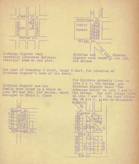
32a
home of her uncle, Judge Smith. Young Jefferson Davis, future president of the Confederacy, was best man at the wedding. These facts were recorded in the old family Bible given to Minerva by her mother, Eliza Putnam Craig, the daughter of Elisha Putnam.
Nicholas and Minerva Rightor returned to Helena and he resumed his life as a surveyor. In 1823 their first son, William Russell Rightor, was born. Probably they lived in the house on Lot 3, which Waldo P. Craig presented to his nephew, their first born son, in January, 1824.
We find no field notes of surveys in the present limits of Phillips County between 1820 and March, 1825, by Nicholas Rightor. This may be why William Russell, on April 12, 1824, wrote to William Rector, Surveyor General of the Territories of Illinois, Missouri, and Arkansas: "Out of the little falling within my own knowledge upon this subject (unprofitable deputies), I will say that Mr. Nicholas Rightor, whom I believe to be a good and accurate surveyor, residing in Arkansas, within my knowledge had several contracts none of which were of the large and profitable sort that were given to some other deputies. It is however just that I add that I have not heard Mr. Rightor complain." We find field notes by Rightor dated Merch 4, 1825, of Township 3 South, Range 1 East, and Russell's letter may have been of some help.
Nicholas had not forgotten his dream of emigrating, as evidenced by this letter in the Texas archives, addressed to "Stephen F. Austin, Esqr. Province of Texas Government of Mexico Politeness of a stranger, and dated "Near Little Rock, October 20, 1825," He wrote: "I have been ever since I returned to the United States surveying for the government, and have just finished a large Dist. (rict)- and will shortly be on my way to St. Louis with my returns. I live at Helena, county of Phillips, A. T. (where I have a wife and two fine boys)". His second son, Nicholas, was born in 1825. He asked about the progress of the colony, and added: "I still have a strong desire to emigrate - I am doing very well here, but notwithstanding I would rather be there."
By 1830 Nicholas and Minerva were the parents of their first daughter, Elizabeth, born in 1827. George King presented his niece, their first daughter, a lot on Water Street, Lot 6, and records show that at one time the post office was located on this site. Nicholas Rightor was an inventive end enterprising man. A legal notice from the Territorial Superior Court shows that on August 25, 1830, he deposited a title of an improvement on the steam engine, and field notes of surveys of the exterior lines of Townships 4 and 5 South, Range 1 East, Township 3 South, Range 2 East, Townships 5 and 6 South, Ranges 2 and 3 East, Townships 4 and 5 South, Range 3 #ast, and Townships 4 and 5S, Range 1 West, made under a contract of April 2, 1829, show that he was also a merchant.
33
On October 28, 1830, while surveying the exterior lines of Townships 4 and 5 South, Range 1 West, he ended his field notes with the following:
"Note: It will be several days before I do any more work, as I have just now recd (by messenger) bad news from home that my dwelling house & store have been consumed by fire- most of the goods and furniture lost. N. Rightor, D.S."
Water Street, in the area of Lot 3, was the principal business district at this time, and evidently Nicholas Rightor had combined his home and business on this lot.
By 1833 Nicholas and Minerva needed a much larger house, their second daughter, Mary Jane, having been born in 1831, and their third son, Henry Clay, in 1833. Nicholas acquired Lot 4 in Old Helena and on Lots 3 and 4 built a tavern house, the Arkansas Hotel, which he leased to James Clark. As a part of the rental, Clark in turn subleased a house owned by Edwin T. Clark on Lots 364 and 365, on the southeast corner of Walker and Columbia Streets, in which the Rightors were then living. In March, 1835, Clark gave up his lease on the Hotel, and in June of that year Rightor sold the lots and the "Arkansas Hotel" to William Strong for $3,000.00, The Rightors evidently gave up the Clark house at this time, for they had built themselves a new home, where Nicholas Rightor was to spend the rest of his life.
In May, 1834, Rightor acquired from the United States the E 1/2 of the SW 1/4 of Section 8, Township 2 South, Range 5 East, which adjoins the Spanish Grant on which the Town of Helena is located. On this piece of land he built himself a house, and later also acquired adjoining tracts of land. The only reference we find as to the location is in the deed to the south 30 acres, now know as the old Phillips County Poor Farm. The north line of this description is along "the top of the hill or ridge south of said Rightor's house." Perry Street Extended now goes through the E 1/2 of the SW 1/4 of Section 8, Minerva P. Rightor was awarded the north part as a part of her dower and homestead after the death of her husband.
The busy surveyor also found time to take active part in the life of the growing town of Helena. At the annual 4th of July barbecue and picnic celebrations he was one of the speakers, and when the son of Griswold Latimer, William Latimer, was murdered, and the townspeople formed a "vigilance committee" to find, apprehend and bring the evildoer to justice, he was one of its members. The murderer, to our knowledge, was not found, but the town was so thoroughly searched and suspicious characters arrested and examined that bad and unsavory inhabitants fled the place and now such trouble was had for a great many years thereafter.
34
Surveyors at that time were hired by contract, paid about $4.00 a mile, and had to make their returns to St. Louis to collect their pay. Rightor added to his income in other ways. About 1837, he went into partnership with George King, his wife's brother-in-law, and built a steam saw and grist mill and brick press about a mile west of the Helena town tract, probably on a part of the Section 8 tract, which is usually referred to as this distance from Helena. Rightor and King had obtained the exclusive right to use a brick machine patented to Nathan Sawyer within the limits of the State of Arkansas. In 1838, George King sold his half interest to Henry L. Biscoe. Another momentous occasion also occurred in 1838: Minerva and Nicholas became the proud parents of twin sons: Oliver and Orlean (called Ollie and Orlie).
Nicholas Rightor also owned land in other parts of the State of Arkansas, and in Coahoma County, Mississippi. He and Robert Lusk, of Nashville, Tennessee, entered 2,041.68 acres in Township 3 South, Range 10 West, on the south bank and adjoining the Arkansas River, on which was situation "the Town of Rightor's Burgh." His administrator also disposed of a steam engin and boilers, and a herd of wild stock in Mississippi, after his death. In June, 1841, we find the last transaction by Rightor. He conveyed a 1/2 interest in a tract of land on the Mississippi River opposite Lots 31 and 32 in the Town of Helena to Henry L. Biscoe for the express purpose of placing thereon the steam mill then owned by the two of them.
On August 18, 1841, Nicholas Rightor died, leaving his widow, Minerva, and seven minor children; William Russell, Nicholas, Elizabeth, Mary Jane, Henry Clay, Oliver, and Orlean. His eighth child, Emma, was born after his death, on January 31, 1842, and little Oliver died in that year.
Nicholas Rightor came to Phillips County before its formation, and stayed to help found its oldest city, to take part in its business and social life, and to leave sons and daughters to live and prosper on its land. He surveyed in a wilderness, where the trails he made were the first to cross a virgin territory, and he died a young man according to our present standards. He was industrious, inventive, interested in the political and business life of the community, and a man who worked hard to provide for his family. Notes in the family Bible show he was a good Bible student. The surveyors of today recognize his competence and reliability as a surveyor. His grave is unmarked only because it cannot be found.
Minerva Putnam Craig Rightor outlived her husband by many years. She and her husband throughout their married life kept a diary and scrapbook, each making entries recording events which took place in their family, and national events of interest to them, keeping clippings, poems, prayers, obituaries, treatments for various illnesses which the mother of the family might need, as she was doctor and nurse for her children and slaves. This journal and scrapbook Minerva continued and the entries she made after his death reveal
35
the fact that she underwent many hardships and sorrows as she reared her family alone. There is an account of the death of her little son Oliver, and, later, the death of a beloved granddaughter, child of Nicholas. There are also some poems which Minerva wrote to and for her grandchildren. A newspaper clipping tells of the occasion when Emma Rightor, the child Nicholas did not live to see, presented the flag to the Phillips County Guards at the beginning of the Civil War as well as one when she was named Miss Arkansas. A notation in the back of the diary reads, "I began this book 1st Jan. 1828," and again, "I began this book second time 1st January, 1829."
The old family Bible bought by Elisha Putnam on February we, 1776, and given by his daughter, Eliza Putnam Craig, to her daughter Minerva contained many items of interest. Minerva was baptised in the Mississippi River at Helena by Jourden Lambert, a Presbyterian minister, in 1838. She was one of the 12 persons who founded a Presbyterian Church in Helena, which was organized May 19, 1849. She later became a member of a Baptist Church when Brother Groves came to Helena and organized it. Marriages, births, and deaths were recorded, as well as dates telling of times at which various members of the family became members of churches.
In 1875, on the occasion of her 75th birthday, Mrs. Rightor held open house for her family end friends. There was an article in the social column of the newspaper of the day which revealed the fact that she was the oldest resident of Helena, greatly loved and respected, and an outstanding citizen. She lived to see most of her children married and established in homes of their own, some in Arkansas and others in Mississippi and elsewhere. She knew the love of many of her grandchildren. She died November 27, 1878, and is buried in the plot of her oldest son, William Russell Rightor, in Maple Hill Cemetery.
The two books, the diaries and scrapbook, and the old family Bible, in 1936, were in the possession of Dr. H. H. Rightor, Minerva and Nicholas' grandson, and the W. P. A. at that time made an outline of the table of contents of both, to which I am indebted for some of the foregoing information. At this time, we are unable to locate either of these valuable books. In the Phillips County Museum, however, is an old whetstone found near Helena by L. R, Parmelee, long City Engineer of the City of Helena, with the initials "N.R." thereone, and presumed to have been the property of Nicholas Rightor. The original plat of Old Helena, the signature of "Nicholas Rightor" still legible although most of it is worn out, hangs on the wall of the Museum, a memento of an illustrious pioneer of our County and the City of Helena.
******
36
I wish to offer my thanks to the many people who so kindly helped me with the preparation of this paper. Among them are:
Mrs. Bertha Cobb Lester, Duncan, Miss., a descendant of Mary Jane Rightor.
Mrs. John T. Caldwell, Jr., Jackson, Miss., a descendant of William Russell Rightor.
The H. H. Rightor family, descendants of Henry Clay Rightor
D. G. Walker
Mrs. J. C. Jeffries, Librarian, Helena Public Library
Miss Dorothy James, Abstracter, Hornor-Morris Abstract Company, Helena
Mrs. C. M. T. Kirkman
Porter Young, of the Helena World
Margaret Smith Ross, of The Arkansas Gazette
Congressman E. C. "Took" Gathings
Dr. John L. Ferguson of The Arkansas History Commission
Miss Mary Devant, Reference Department, Cossitt Library, Memphis
Charles Purvis, County Surveyor
John C. King, Jr.
***
BIBLIOGRAPHY
D. A. R. Application Paper No, 95976
Territorial Papers of the United States, Vols. XIX and XX, Territory of Arkansas
Deed Record Books A, B, C, D, E, and F, official records of Phillips County, Arkansas
Original Field Notes of U. S, Government Survey, copied by the WPA, in official records of Phillips County, Arkansas.
Marriage Record Index Book 1, official records of Phillips County
Probate Record Books 3 and 4, official records of Phillips County
Adams County, Mississippi, Marriage Record Book 3, page 10
Survey of State and Local Historical Records, County of Phillips, WPA, 1936, Index of Rightor Bible and Scrapbook
Mrs. John N. Ware scrapbook, Helena Public Library
“Pictorial History of Arkansas," by Fay Hempstead
“America's Best Buy, The Louisiana Purchase," by Charles Nutter
“Pioneers and Makers of Arkansas," by Josiah H. Shinn
Letters from Margaret Smith Ross, Arkansas Gazette
Letters from Dr. John L. Ferguson, Arkansas History Commission
Letters and maps from Congressman E. C. "Took" Gathings
Letter from The Library of Congress
Letters from Mrs. Bertha Cobb Lester and Mrs. John T. Caldwell, Jr.
"Arkansas Pioneer, Traveler: Founder of Helena", by Pearl Hendricks, Arkansas Gazette, Little Rock, Sunday, September 10, 1944.
***
37
If you have questions or problems with this site, email the TCGS Coordinator, Ms. Carrie Davison, or the Webmaster, Ms. Debra Hosey.
Please do not ask for specific research on your family here. Use the
Research Help page instead.